
17/11/2025
In 1998, the first Law on Water Resources was promulgated, by 2023 the Law was amended and supplemented, marking a turning point in management, protection and development of water resources. In particular, the State’s policy on water resources clearly states: Modernize and professionalize water resources management towards national governance of water resources on a digital technology platform through the National information system and database on water resources, and decision support tool system, ensuring efficient use of resources in water resources management [1]. Since the Law on Water Resources 2023 took effect, the Ministry of Natural Resources and Environment (now the Ministry of Agriculture and Environment) has directed the application of scientific and technological achievements in water resources management to use resources effectively and efficiently, especially in supervisingwater resources, operating inter-reservoirs, forecasting drought & water shortage and water resources scenarios, building the National database on water resources to ensure that it is “Correct, sufficient, clean, and alive”. The article focuses on results: (i) Supervising water resources on the IoT platform; (ii) Implementing the inter-reservoir operation process on the digital technology and IoT platform; (iii) Real-time drought map on the basis of digital technology; (iv) Organizations and individuals exploiting and using water, conducting baseline surveys of water resources, must update information and data into the National information system and database on water resources for management, implementation of policies promptly and effectively [2].
1. SUPERVISING WATER RESOURCES ON THE IOT PLATFORM
1.1. Model of supervising water resources
Realizing that promoting the application of advanced solutions and technologies to effectively manage water resources, focusing on the application of information technology in water resources management is an urgent requirement, since 2018 the Department of Water Resources Management has coordinated with the Department of Digital Transformation and Environmental Resources Data Information to develop a Supervision system on exploitation and use of water resources (https://iot.monre.gov.vn/ tnn/).With set objectives, including: Online tracking and supervising surface water exploitation and use works; underground water exploitation and use works licensed by the Ministry of Natural Resources and Environment (now the Ministry of Agriculture and Environment) (supervision according to license), the design is based on open standards to ensure connection, communication, integration and sharing of information and data with systems of 63 provinces/ cities nationwide; connection, communication with existing systems for monitoring water flowrate, level and quality of irrigation and hydropower reservoirs under the issued inter-reservoir operation process; automatic or manual information update (water flowrate, level, quality and images) into the system for supervising and warning.
Water resources supervision is implemented according to two models: General model of water resources monitoring and supervision system; Integrated and shared linkage model (Figures 1,2). Following is a description of model components.
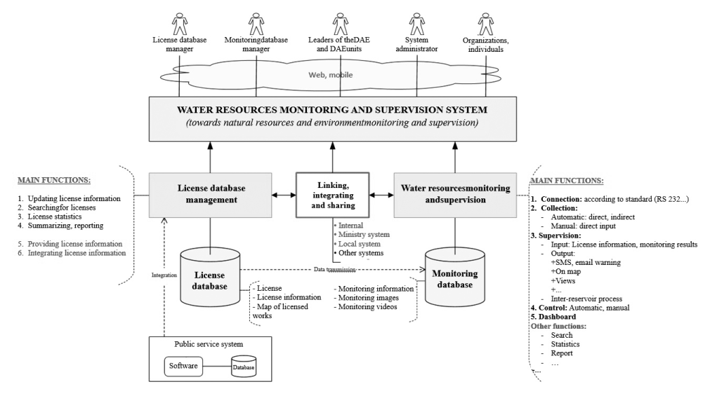
Figure 1. General model of the water resources monitoring and supervision system
Figure 2. Integrated, shared linkage model
Direct and continuous data sources: Information is directly collected from measuring equipment located at facilities with water resources exploitation and use works; Monitoring equipment: Sensors, Protocols send data from monitoring stations, Data sending/receiving devices at the station have IP addresses and can be connected to the Internet.
The frequency of sending information from the device depends on the type of water resources exploitation and use works as prescribed in Circular No. 17/2021/ TT-BTNMT dated 14 October 2021 of the Ministry of Natural Resources and Environment on supervision of water resources exploitation and use; Decree No. 53/2024/ ND-CP dated 16 May 2024 of the Government detailing the implementation of a number of articles of the Law on Water Resources.
Camera supports H264 or H265 image compression standard; supports remote control standards (taking pictures, recording videos) according to OnVif standard.
Other data sources: Data is connected and shared from database systems of local Departments of Agriculture and Environment; from database systems of the Vietnam Meteorological and Hydrological Administration, the National Center for Water Resources Planning and Investigation; Data is linked and shared from relevant ministries and sectors; Data is connected, synchronized and shared from the national database system on natural resources and environment monitoring.
Technological solutions: Collect data, receive information and data from monitoring stations and real-time surveillance cameras at water resources exploitation and use works; Connect, link, and share data from database systems of units under the Ministry (Vietnam Meteorological and Hydrological Administration, National Center for Water Resources Planning and Investigation, etc.), ministries, sectors, and local authorities; Support for additional input and conversion of data on water resources licensing of the Ministry of Agriculture and Environment into the system; Manage, organize, operate the database, build a software group to manage and operate the database.
Exploiting and sharing information and data: Support data analysis and processing for warning and forecasting; publish and share information; build a software group to support data analysis and processing, publish and share information.
Deployment plan: The system is deployed centrally at the Data Center of the Ministry of Agriculture and Environment on the WAN/Internet environment.
1.2. Results of implementing the water resources supervision system
As of the end of April 2025, the system had updated a total of 13,507 water resources licenses of all types to the system, including 2,270 ministerial-level licenses and 11,237 provincial-level licenses.
In addition, implementing Circular No. 17/2021/ TT-BTNMT dated 14 October 2021 stipulating the supervision of water resources exploitation and use and Decree No. 53/2024/ND-CP dated 16 May 2024 detailing the implementation of a number of articles of the Law on Water Resources, by the end of April 2025, 58 Departments of Agriculture and Environment had updated and connected information of local water resources licenses to the central database of shared information of water resources licenses; 5 Departments of Agriculture and Environment (Hoa Binh, Dong Nai, Vinh Long, Bac Lieu, Ca Mau) had not updated. As of April 2025, 11,237 water resources licenses of all types issued by provincial-level People’s Committees had been entered into the water resources supervision system.
Implementing provisions of the Law on Water Resources 2023 and Decree No. 53/2024/ND-CP of the Government on guiding the implementation of the Law on Water Resources, in April 2025, a number of Departments of Agriculture and Environment contacted to test and connect works licensed by local authorities to the system (Departments of Agriculture and Environment: Ho Chi Minh City; Nghe An, Quang Ninh, Ninh Thuan, Thai Nguyen).
Along with that, as of April 2025, the water resources supervision system had 831 water resources exploitation works subject to licensing by the Ministry of Agriculture and Environment registered and connected to transmit data to the system. Of which, the Department of Water Resources Management successfully approved the connection to transmit data to the system for 810 works (surface water works: 697; underground water works: 111; seawater works: 2).
The water resources supervision system has been built, put into operation and has brought initial results, actively supporting the management work at the
Central level and local levels. From the data of connected works, transmitted to the Central water resources supervision system, it has effectively contributed to the management and operation work, making decisions for the state management of water resources of the Department of Water Resources Management such as: Collecting and storing data from monitoring stations of organizations and individuals exploiting and using water resources to ensure convenience, efficiency and speed; Synthesizing, analysing and building related charts and graphs; Providing statistical data by time, type, by administrative unit, river basin; Searching and managing information; Displaying monitoring stations on the map; Giving warnings and notifications when there are signs about to exceed the threshold or when the prescribed threshold has been exceeded; Extracting data, making reports on the list and information about connected works.
2. IMPLEMENTING THE INTER-RESERVOIR OPERATION PROCESS ON THE DIGITAL TECHNOLOGY AND IoT PLATFORM
According to Point a, Clause 5, Article 60 of the Law on Water Resources 2012 and Clause 7, Article 38 of the Law on Water Resources 2023: the Ministry of Natural Resources and Environment (now the Ministry of Agriculture and Environment) shall develop and adjust the inter-reservoir operation process on river basins and submit it to the Prime Minister for approval.
In order to carry out assigned tasks, in the past time, the Ministry of Agriculture and Environment has developed and completed 11 inter-reservoir operation processes on 11 large and important river basins (processes are reviewed and updated regularly). After having issued, the Ministry has directed competent authorities to regularly supervise and examine the operation of reservoirs according to provisions of inter-reservoir operation processes on 11 river basins issued by the Prime Minister. With a total of about 134 reservoirs and dams on 11 river basins regulated and operated according to the inter-reservoir mechanism with the principle of top priority during the flood season being to ensure the safety of works, cut and reduce floods for downstream areas, prioritize maintaining minimum flow, and supply water to downstream for production and people’s lives in the dry season. Of which, there are 37 reservoirs having regulations on flood prevention capacity with a total flood prevention capacity of about 12 billion m3 (about 22% of the total capacity of all reservoirs) and in case of flood, this capacity can reach a maximum of 13 billion m3 (about 24% of the total capacity of all reservoirs).
Based on provisions in inter-reservoir operation processes, the Ministry of Agriculture and Environment is responsible for directing the Department of Water Resources Management and relevant agencies to inspect, examine and supervise the operation of reservoirs according to these processes and organize the development of supervision and calculation tools to support for advising for directing the operation of reservoirs according to its authority.
To fulfil tasks under the responsibility of the Ministry of Agriculture and Environment, the Department of Water Resources Management is currently using the reservoir operation data information system for the direction and operation work, built since 2015 (https://quanly.dwrm.gov.vn/hochua). The current system has received operation data of more than 134 reservoirs applying inter-reservoir operation processes on 11 river basins (including rivers: Red; Ma; Ca; Huong; Vu Gia - Thu Bon; Tra Khuc; Kon - Ha Thanh; Ba; Se San, Srepok; Dong Nai). Necessary information for the process of supervising and examining the operation of reservoirs according to provisions of inter-reservoir operation processes, as a basis for directing the operation of reservoirs, includes: (1) Monitoring data on water level of reservoirs, inflow to reservoirs, discharge through dams, discharge through power generation; (2) Monitoring data on water flowrate and level, time when water level at hydrological stations reaches water level value according to alarm levels and provisions in inter-reservoir operation processes; forecast and warning bulletins...
The operation information and data that the reservoir management unit updates to the system is an important basis for analysing and evaluating the compliance with provisions of inter-reservoir operation processes on 11 river basins and is the basis for the Department of Water Resources Management to promptly urge and guide reservoir owners to strictly implement the operation to ensure cutting and reducing floods for downstream areas and coordinate the operation and regulation of reservoirs to ensure supplying water to downstream areas during the dry season, periods of drought and water shortage on river basins and according to provisions of inter-reservoir operation processes on 11 river basins through the form of documents, telephone, email... (Every year, over 100 documents are sent to reservoir owners and local authorities to urge, guide and direct the operation).
In addition, direct specialized agencies to regularly provide timely forecasts and warnings to local authorities and reservoir owners; urge for the strict implementation of provisions of inter-reservoir operation processes. Send working groups to conduct field surveys in flooded areas in some provinces and cities such as Da Nang City, Quang Nam, Hue City... and reservoirs; work, exchange; support the direction and operation; answer, guide, and remove obstacles in the operation of reservoirs according to processes. For the dry season, send working groups to work with local authorities to unify plans to direct and regulate water in reservoirs, especially during times of drought and water shortage to ensure the operation of reservoirs to supply enough water to downstream areas of river basins (Figure 3).
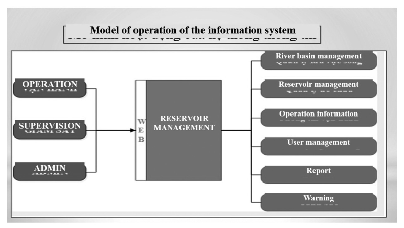
Figure 3. Model of operation of the information system for reservoir operation for the direction and operation
3. REAL-TIME DROUGHT MAP ON THE DIGITAL TECHNOLOGY PLATFORM
Vietnam is one of countries heavily affected by climate change, having extreme weather and climate phenomena occurring with increasing frequency such as unusual floods, prolonged droughts, and saltwater intrusion. River basins, especially downstream areas such as Red - Thai Binh, Dong Nai - Sai Gon, are key socio-economic areas, ensuring food security and water security. However, in the context of increasingly complex climate change, along with the rapidly increasing demand for water exploitation and use, water sources in river basins are facing many serious challenges.
Faced with this situation, the proactive development of water sources scenarios is an urgent requirement, as a basis for ministries, sectors and provincial level People’s Committees in river basins, within the scope of their tasks and powers, to direct the planning for appropriate exploitation and use of water resources. This is also one of key tasks to implement Resolution No. 57-NQ/TW dated 22 December 2024 of the Politburo on breakthroughs in the development of science, technology, innovation and national digital transformation. Water sources scenarios (for example, drought scenarios in the Red - Thai Binh river basin) not only provide information to forecast and warn of drought risks but also support the regulation and distribution of water resources in river basins, contributing to ensuring water security, food security, energy security and other essential needs of the people.
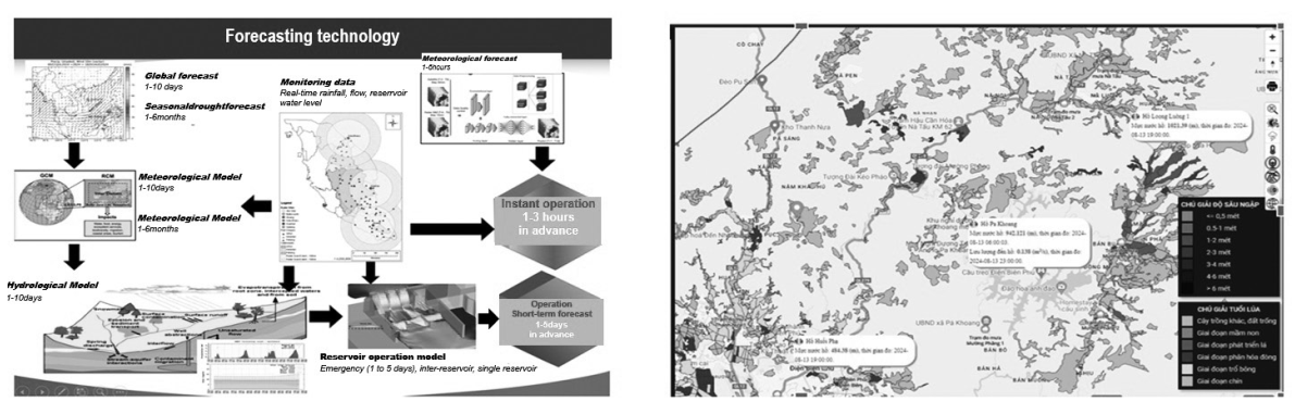
Real-time drought mapping technology based on forecasting technology, integrated modeling and big data
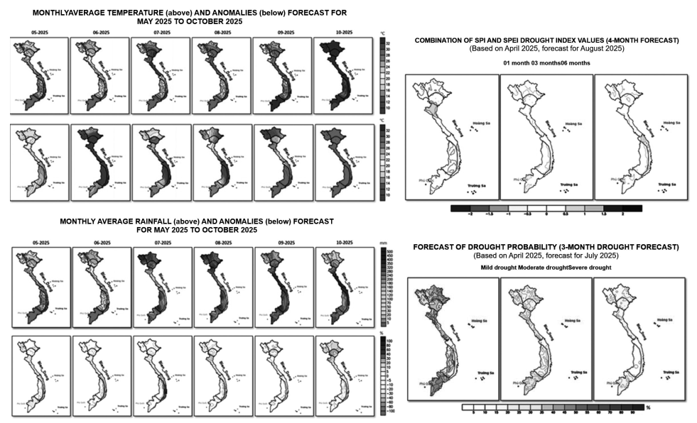
Real-time drought severity and drought probability forecast map products updated monthly
Methods for developing drought scenarios: The process of developing drought maps and water sources scenarios synchronously applies modern digital transformation technologies, specifically according to following steps:
Collecting and processing big data: The process of developing drought maps and drought scenarios is based on the collection, synthesis and analysis of continuously updated big data sources, including: data on rainfall, flow, reservoir water volume, groundwater level and water demand...
Applying digital models: All data are integrated into a centralized management system, allowing quick update, synchronization and retrieval; Build and apply a combination of digital models for forecasting seasonal rainfall to forecast rainfall for next 6 months to provide information to scenarios; Apply hydrological models to forecast water flow and level variations at reservoirs; Use methods/algorithms to analyse drought trends and assess water shortage risks by region and sub-region.
Zoning drought areas and building digital maps: Based on simulation results, areas are divided according to the level of water shortage: mild, moderate, severe; Build drought maps on the GIS platform: Drought zones are visually represented on digital maps, helping users easily identify affected areas, severity and developments over time.
Developing water sources scenarios: Establish water sources development scenarios based on rainfall trends, water flow trends, total water storage in hydroelectric reservoirs, water levels in underground aquifers and exploitation and usage needs of sectors. From there, analyse the impact of each scenario on water supply to domestic, agricultural and hydropower activities.
Outstanding products of the digital transformation process: The monthly drought/rain forecast bulletin/ map is updated periodically, providing information on rainfall trends, thereby providing warnings about lack of rainfall; The forecast bulletin/map of river flows and reservoirs based on rainfall trends provides the flow trends of major rivers and the amount of water stored in large reservoirs to provide early warnings to local authorities and production sectors to proactively respond to water shortages; Drought map by region and time displays areas with water shortages.
4. ORGANIZATIONS AND INDIVIDUALS EXPLOITING AND USING WATER, CONDUCTING BASELINE SURVEYS OF WATER RESOURCES, MUST UPDATE INFORMATION AND DATA INTO THE NATIONAL INFORMATION SYSTEM AND DATABASE ON WATER RESOURCES
This is a big step forward in development of a database on water resources specifically stipulated in the Law on Water Resources, including: The Ministry of Agriculture and Environment organizes the development, management, operation, and maintenance of the national information system and database on water resources; updating information and data on water resources [3]; Organizations and individuals conducting baseline surveys of water resources using the state budget must update information and results of baseline surveys of water resources into the National information system and database on water resources
[4]; The Ministry of Agriculture and Environment organizes the implementation of inter-provincial river basin master plan; updating information and data on inter-provincial river basin master plan records into the National information system and database [5]; Provincial-level People’s Committees shall consider and decide on the conversion of purposes of use of mineral, soil and building material mining pits after the mining has stopped to form reservoirs for water regulation, storage, supply and landscape creation when meeting all requirements prescribed by this Law, legislation on investment, land, environmental protection, minerals and update and supplement the list of intra-provincial surface water sources and the list of reservoirs, ponds, lagoons and estuaries that must not be filled [6]; Results of monitoring water resources, hydrometeorology and water environment quality must be updated and shared to the National information system and database on water resources [7]; Organizations and individuals exploiting water resources are responsible for updating, connecting, and transmitting monitoring data to the National information system and database on water resources for supervision of water resources exploitation [8]; Underground water exploitation works of households specified in Clause 4, Article 52 of the Law on Water Resources must be declared [9]; Cases of works exploiting and using water resources must be registered [10]; Declaration and registration are carried out on the application for declaration and registration of exploitation and use of water resources [11]; Districtlevel People’s Committees and Communal-level People’s Committees organize for updating of data on underground water exploitation registration in the area into the National information system and database on water resources [12].
Nguyễn Minh Khuyến, Trần Thị Thanh Tâm
Department of Water Resources Management
(Source: The article was published on the Environment Magazine by English No. III/2025)
REFERENCES
1. Article 4 of the Law on Water Resources.
2. Article 7 of the Law on Water Resources.
3. Clause 5, Article 7 of the Law on Water Resources.
4. Clause 5, Article 10 of the Law on Water Resources.
5. Clause 4, Article 18 of the Law on Water Resources.
6. Clause 5, Article 27 of the Law on Water Resources.
7. Point đ, Clause 1, Article 51 of the Law on Water Resources.
8. Point b, Clause 2, Article 51 of the Law on Water Resources.
9. Clause 1, Article 8 of Decree No. 54/2024/ND-CP stipulating the practice of underground water drilling, declaration, registration, licensing, services of water resources and fees for granting the right to exploit water resources.
10. Clause 2, Article 8 of Decree No. 54/2024/ND-CP.
11. Point a, Clause 1, Article 25, Decree No. 54/2024/ND-CP.
12. Clause 4, Article 57, Decree No. 54/2024/ND-CP.