
03/08/2024
World Environment Day (June 5th, 2024) and the World Day to Combat Desertification and Drought (June 17th, 2024) both have themes related to a global issue that affects the ecological security of the planet, poverty reduction, socio-economic stability, and sustainable development. The themes are "Restoring land, Combating drought and desertification" and "Managing and using land sustainably, Our heritage - Our future". It shows the concern of humanity about the environmental challenges, which are warned to be the greatest of all time, impacting all aspects of social life, livelihoods, and the environment.
1. Introduction
Vietnam's land is at risk of decreasing both in quantity and quality due to the conversion of agricultural land to other purposes due to industrialization, urbanization, socio-economic development, national defense and security, new rural development, as well as land degradation. Many fertile areas are experiencing declining quality due to erosion, reduced soil fertility, drought, desertification, compaction, laterite formation, salinization, and acidification. The process and degradation are occurring in most natural geographic and economic regions of the country, both in agricultural and forestry lands. The area of degradation from low to high accounts for up to 15.07% of the total natural area, concentrated in the Midlands and Northern Mountains, North Central Coast, and Central Coast regions. Enhancing organic matter, controlling land use changes, sustainable land and water management are the strategies for combating desertification in Vietnam.
Many countries, including Vietnam, have developed national action program to combat desertification. On September 2nd, 2006, the Prime Minister issued Decision No. 204/2006/QD-TTg on the Promulgation of the National Action Program to Combat Desertification for the period 2006 - 2010 and orientation to 2020, in order to implement the UN Convention to Combat Desertification and concretize the orientation of the Sustainable Development Strategy in Vietnam (Vietnam's Agenda 21). Accordingly, the Ministry of Agriculture and Rural Development is the lead agency for the National Action Program to Combat Desertification for the period 2006 - 2010 and orientation to 2020.
According to the Convention, desertification is land degradation in arid, semi-arid, and dry sub-humid areas due to various factors, including climate change and human activities. Land degradation is the process of reducing or losing the biological productivity and the ability to provide economic benefits of the land. Arid, semi-arid, and dry sub-humid areas are regions with an evaporation to precipitation ratio of about 0.05 to 0.60. In Vietnam, combating desertification means preventing the risk of land degradation, limiting the process of land degradation in semi-arid, arid, and dry sub-humid areas; restoring and rehabilitating degraded and wasteland by enhancing the role and responsibility of government agencies, along with promoting socialization so that households, enterprises, and social organizations participate in protecting and sustainably developing land, forest resources, preventing salinization, acidification, and mobile sand, and developing irrigation to improve livelihoods for people affected by desertification [3]. Initially, the Convention was only concerned with arid regions, but later it expanded its activities to prevent and combat land degradation.
According to Decree No. 204/2006/QD-TTg, the guiding principles for combating desertification include: (1) Combating desertification is a particularly important task, contributing to the sustainable management of natural resources, water resources and land, gradually increasing the income of the people, eradicating hunger, reducing poverty, and firmly resolving the task of resettlement and sedentarization. (2) The fight against desertification must be carried out in a scientific and effective manner, based on a unified and coherent system of state policies and laws, with a sense of succession and under the centralized and synchronous guidance of the Government; concretized through projects implemented by ministries, sectors, political-social organizations, and local People's Committees affected by desertification, mobilizing the attention and contribution of the whole society. (3) Expanding, diversifying, and multilateralizing international relations, but with a focus on concentrating investment and attracting investment from all economic sectors both domestic and foreign, strengthening the staff and absorbing modern technology, and inheriting suitable traditional experiences, contributing to the effective implementation of the National Action Program to Combat Desertification and multilateral environmental commitments (MEAs). (4) Closely combining economic development, social development, and environmental protection, ensuring national defense, security, and social safety and order, linking the National Environmental Protection Action Program as well as other national strategies and programs with the implementation of the United Nations Millennium Development Goals (MDGs).
2. Current status of agricultural land degradation in Vietnam
2.1. Current status of agricultural land in 2022
Table 1: Current status of agricultural land nationwide in 2022
|
Order |
Land type |
Code |
Area (ha) |
Percentage (%) |
|
|
Total agricultural land area |
NNP |
28.002.574 |
100 |
|
1 |
Agricultural production land |
SXN |
11.673.357 |
41,69 |
|
1.1 |
Land for annual crop cultivation |
CHN |
6.753.636 |
24,12 |
|
1.1.1 |
Rice cultivation land |
LUA |
3.930.351 |
14,04 |
|
1.1.1.1 |
Land dedicated to wet rice cultivation |
LUC |
3.190.965 |
11,40 |
|
1.1.1.2 |
Remaining land for wet rice cultivation |
LUK |
639.490 |
2,28 |
|
1.1.1.3 |
Upland rice cultivation land |
LUN |
99.895 |
0,36 |
|
1.1.2 |
Land for cultivation of other annual crops |
HNK |
2.823.285 |
10,08 |
|
1.1.2.1 |
Flat land for cultivation of other annual crops |
BHK |
1.053.522 |
3,76 |
|
1.1.2.2 |
Upland land for cultivation of other annual crops |
NHK |
1.769.763 |
6,32 |
|
1.2 |
Land for perennial crops |
CLN |
4.919.721 |
17,57 |
|
2 |
Forestry land |
LNP |
15.467.658 |
55,24 |
|
2.1 |
Production forest land |
RSX |
8.025.301 |
28,66 |
|
2.1.1 |
Production forest land is natural forest |
RSN |
3.868.691 |
13,82 |
|
2.1.2 |
Production forest land is planted forest |
RST |
3.210.013 |
11,46 |
|
2.1.3 |
Land being used for Conservation and Sustainable Use (RAX) |
RSM |
946.598 |
3,38 |
|
2.2 |
Protective forest land |
RPH |
5.123.285 |
18,30 |
|
2.2.1 |
Protective forest land is natural forest |
RPN |
4.016.676 |
14,34 |
|
2.2.2 |
Protective forest land is planted forest |
RPT |
599.697 |
2,14 |
|
2.2.3 |
Land being used for protection and development of protective forest |
RPM |
506.911 |
1,81 |
|
2.3 |
Forest land with special-use forest designation |
RDD |
2.319.072 |
8,28 |
|
2.3.1 |
Forest land with special-use forest designation is natural forest |
RDN |
2.083.974 |
7,44 |
|
2.3.2 |
Forest land with special-use forest designation is planted forest |
RDT |
104.658 |
0,37 |
|
2.3.3 |
Land being used for protection and development of RDM |
RDM |
130.439 |
0,47 |
|
3 |
Land for aquaculture farming |
NTS |
783.930 |
2,80 |
|
4 |
Land for salt production |
LMU |
15.373 |
0,05 |
|
5 |
Other agricultural land |
NKH |
62.256 |
0,22 |
Source:MONRE, 2022
The data in Table 1 shows that forestry land and agricultural production land are the two main types of agricultural land, in which natural protection, special-use, and production forests account for 35.6% of the total agricultural land area. In agricultural production land, rice cultivation land and perennial crop land are the main types, with an area of 3,930,351 ha, accounting for 14.04%, and 4,919,721 ha, accounting for 17.57% of the total agricultural land area, respectively; these are the types of land that are crucial to the food security and livelihoods of rural people in both the delta and midland/mountainous regions. Meanwhile, the risk of desertification is emerging even in areas that were previously considered fertile, but due to unsustainable farming practices, land degradation has occurred.
2.2 Status of agricultural land degradation
2.2.1 Area of degradation
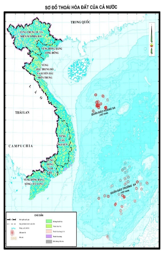
According to the General Department of Land Administration (2020), the agricultural land in Vietnam is mainly assessed as having a mild to moderate level of degradation, with the area of severe degradation only accounting for 4.14% of the total surveyed area and 3.64% of the total natural area. The areas with severe degradation are mainly located in Northern Midlands and Mountains (619,000 ha) and North Central Coast and Central Coast (455,000 ha). The area of moderately degraded land is mainly distributed in Northern Midlands and Mountains (1,839,000 ha) and North Central Coast and Central Coast (889,000 ha).
Table 2. Current status of agricultural land degradation in 2020
|
Order |
Degree of degradation |
Area (ha) |
Percentage (%) |
Compared to the surveyed area (%) |
Compared to the natural area (%) |
|
1 |
Severe degradation |
1.207.000 |
10,20 |
4,14 |
3,64 |
|
2 |
Moderate degradation |
3.787.000 |
31,99 |
13,00 |
11,43 |
|
3 |
Mild degradation |
6.844.000 |
57,81 |
23,49 |
20,66 |
|
|
Total |
11.838.000 |
100,00 |
40,63 |
35,73 |
Source: General Department of Land Administration, 2020
The severely degraded land is mainly found on the following types of land: 800,000 ha of unused land (accounting for 2.42% of the total natural land area), 293,000 ha of forestry land (accounting for 0.88% of the total natural land area), and 114,000 ha of agricultural production land (accounting for 0.34% of the total natural land area). The moderately degraded land is mainly found on the following types of land: 1,655,000 ha of agricultural production land (accounting for 5.00% of the total natural land area), 1,367,000 ha of forestry land (accounting for 4.13% of the total natural land area), and 753,000 ha of unused land (accounting for 2.27% of the total natural land area).
Table 2. Current status of degradation by land use type
|
Order |
Land type |
Area (ha) |
Percentage (%) |
Compared to the natural area (%) |
|
1 |
Agricultural production land |
5.077.000 |
23,21 |
15,33 |
|
1.1 |
- Severe degradation |
114.000 |
0,52 |
0,99 |
|
1.2 |
- Moderate degradation |
1.655.000 |
7,56 |
14,36 |
|
1.3 |
- Mild degradation |
3.308.000 |
15,12 |
28,71 |
|
2 |
Forest land |
4.969.000 |
22,71 |
15,00 |
|
2.1 |
- Severe degradation |
293.000 |
1,34 |
1,97 |
|
2.2 |
- Moderate degradation |
1.367.000 |
6,25 |
9,19 |
|
2.3 |
- Mild degradation |
3.309.000 |
15,12 |
22,25 |
|
3 |
Aquaculture land |
93.000 |
0,43 |
0,28 |
|
4 |
Unused land |
1.693.000 |
7,74 |
5,11 |
|
|
Total |
21.785.000 |
100,00 |
|
Source: General Department of Land Administration, 2020
The severely degraded forestry land is mainly found in the hilly and mountainous areas, which are predominantly affected by erosion, leaching, and a decline in soil fertility due to poor vegetation cover. These are the areas where the forests have been significantly degraded.
Source: General Department of Land Administration, 2020
The degradation of aquaculture land is primarily due to saltwater intrusion in the coastal specialized farming areas, and in some areas, it is also caused by the unplanned conversion of rice cultivation land to brackish and saline aquaculture.
3.2.2. Processes of land degradation
The land degradation processes across the country are not uniform, but rather depend on the characteristics of each region. They can be primarily categorized into 5 main degradation processes. Among these, degradation due to the processes of drought, desertification, and a decline in soil fertility are the most prominent.
Table 3: Processes of land degradation
|
Order |
Erosion process |
Area (ha) |
Percentage (%) |
Compared to the natural area (%) |
|
1 |
Washout process |
13.358.000 |
29,67 |
40,33 |
|
2 |
Process of soil fertility decline |
13.417.000 |
29,80 |
40,51 |
|
2.1 |
Severe decline |
1526000 |
3,39 |
4,61 |
|
2.2 |
Moderate decline |
4.409.000 |
9,79 |
13,31 |
|
2.3 |
Mild decline |
7481000 |
16,61 |
22,58 |
|
3 |
Process of drought and desertification |
16.773.000 |
37,25 |
50,64 |
|
3.1 |
Severe decline |
1.449.000 |
3,22 |
|
|
3.2 |
Moderate decline |
0,00 |
||
|
3.3 |
Mild decline |
0,00 |
||
|
4 |
Process of conglomeration and lateriticization |
1156000 |
2,57 |
3,97 |
|
4.1 |
Severe conglomeration |
194.000 |
0,43 |
0,58 |
|
4.2 |
Moderate conglomeration |
369.000 |
0,82 |
1,11 |
|
4.3 |
Mild conglomeration |
594.000 |
1,32 |
1,79 |
|
5 |
Process of salinization |
197.000 |
0,44 |
0,59 |
|
5.1 |
Severe salinization |
47.000 |
0,10 |
1,14 |
|
5.2 |
Moderate salinization |
43.000 |
0,10 |
0,13 |
|
5.3 |
Mild salinization |
107.000 |
0,24 |
0,32 |
|
6 |
Process of acidification |
125.000 |
0,28 |
0,38 |
|
6.1 |
Severe acidification |
81.000 |
0,18 |
0,24 |
|
6.2 |
Moderate acidification |
17.000 |
0,04 |
0,05 |
|
6.3 |
Mild acidification |
27.000 |
0,06 |
0,08 |
|
Total |
45.026.000 |
100,00 |
Source: General Department of Land Administration, 2020
3. Causes and solutions for combating desertification in Vietnam
3.1. Main causes of land degradation
Firstly, decline in soil fertility due to monoculture, intensive cultivation, and overuse of chemical fertilizers and pesticides, especially in concentrated, large-scale production areas with limited use of organic and microbial fertilizers, leading to soil acidification, loss of organic matter, and nutrient depletion.
Secondly, conversion of land use in coastal areas from rice fields and annual crops to aquaculture, leading to salinization and acidification in the Mekong Delta, especially in the provinces of Ca Mau, Bac Lieu, Soc Trang, and Tra Vinh.
Thirdly, shift cultivation practices (swidden agriculture) of ethnic minority groups leading to soil erosion and loss.
Fourthly, degradation and fragmentation of irrigation systems in the delta regions due to urbanization, industrialization, and new rural development.
Fifthly, in forestry, widespread deforestation, unsustainable logging practices (clear-cutting), and agricultural production on forestland, leading to soil erosion, deterioration of forest soil properties, and desertification, especially in Central Highlands and Northwest regions.
3.2. Solutions to prevent desertification
Firstly, increase the application of organic fertilizers, utilize organic materials after harvesting to supplement soil organic matter, intercrop or rotate with leguminous crops and other nitrogen-fixing plants to improve soil health.
Secondly, strictly control land use changes in coastal areas, protect and plant mangrove forests along the coast in combination with investment in dyke systems, irrigation, and hydraulic structures to limit saline intrusion, leach acidic salts, and shift crop structures appropriately. Research saline-tolerant and climate-adaptive crop varieties.
Thirdly, strengthen inspection and monitoring in forest management, protection, and development, protect water resources, especially in Northwest and Central Highlands regions. Continue to apply support mechanisms and policies for people engaged in forestry through programs like payments for forest environmental services and carbon credit trading. Promote and guide techniques for sustainable cultivation of sloping lands such as terracing, agro-forestry, home gardens, and fixed shifting cultivation depending on slope levels to ensure sustainability.
Fourthly, invest in the development of high-tech agriculture, eco-agriculture, organic agriculture, experimental agriculture models, agri-tourism, and community-based agricultural learning on concentrated agricultural lands or interspersed in new urban areas, non-industrial, in association with new rural development to increase incomes and promote sustainable development.
Fifthly, survey, demarcate, and issue land use right certificates for forest land and land originated from state-owned farms and plantations to be allocated to ethnic minority groups lacking land. Establish agricultural land databases, develop digital maps of soil organic carbon in Vietnam, soil quality maps, and land degradation maps to monitor changes in soil organic matter content, soil quality, and land degradation.
Dr. NGUYỄN BÁ LONG
Director of the Institute of Land Administration and Rural Development,
University of Forestry
(Source: The article was published on the Environment Magazine by English No. II/2024)
REFERENCES
1. Ministry of Agriculture and Rural Development (2024). Decision No. 1489/2024/QD-BNN dated May 30, 2024 of the Minister of Agriculture and Rural Development on the consolidation of the national coordination committee for the implementation of the United Nations Convention to Combat Desertification.
2. Ministry of Natural Resources and Environment (2022). Decision No. 3048/QD-BTNMT dated October 18, 2023 on Approving and Announcing the Results of Land Area Statistics in 2022.
3. United Nations (1992). United Nations Convention to Combat Desertification, United Nations Conference on Environment and Development, Rio de Janeiro.
4. Prime Minister (2006). Decision No. 204/2006/QD-TTg dated September 2, 2006 of the Prime Minister on Issuing the National Action Program to Combat Desertification in the period of 2006 - 2010 and orientation to 2020.
5. General Department of Land Administration (2020). Comprehensive Report on Land Degradation Survey and Assessment Nationwide, Project "National Land Resources Survey and Assessment" (Component I: Land Survey and Assessment of the Whole Country, Socio-economic Regions)".