
20/11/2023
Abstract:
Flooding in Ho Chi Minh (HCM) City is caused by heavy rain, high tide, flood discharge from upstream, urbanization-land subsidence and climate change. Simulation programs used for flood control of downstream of the Dong Nai river system basin, including model of rainfall flow (NAM) and hydraulic model (MIKE 11). Simulation scenarios include tidal flooding in consideration of urbanization-land subsidence and climate change in the area. The urbanization data by the year of 2030 is used in accordance with urban space development planning. The impacts of the urbanization-land subsidence, climate change and implementation of the Irrigation Plan 1547 by the year of 2030 is considered according to the scenario of 2030RCP4.5 as the baseline for comparison and the scenario of 2030RCP4.5_P1547. Predicted results show that water levels in the main river as well as in the urban area have increased significantly, resulting in increased flooded areas.
Keywords: Flooded area, climate change, urbanization-land subsidence, simulation scenarios.
JEL Classifications: Q54; R00; R28.
Received: 5th July 2023; Revised: 5th August 2023; Accepted: 30th September 2023.
Introduction
HCM City is a coastal city, with an intricate network of rivers and canals (about 2,953 routes with total length of about 4,371km), low terrain (about 75% of the area has an elevation of less than 2 m), and rapid land subsidence over 1.0 cm/year over a large area of about 240 km2, therefore, flooding often occurs, causing serious damage to property, disrupting production processes, limiting public transportation, increasing disease and negatively impacting environmental quality.
Flooding in HCM is caused by heavy rain, high tides, flood discharge from upstream, urbanization-land subsidence and climate change. According to statistics from the authorities, by the end of 2016, the City had 105 flooded points, including 47 points flooded due to rain, 7 points flooded due to tide and 51 points flooded due to rain combined with high tide.
Implementation of the Irrigation Plan to prevent flooding in HCM City area approved by the Prime Minister according to Decision No. 1547 (the Plan 1547) [2] will improve the flood situation in the city.
This paper will present an assessment of the impact of urbanization-land subsidence, climate change and implementation of the Irrigation Plan 1547 on flooding in Ho Chi Minh city by the year of 2030.
2. Reseacrh and methodology
1. Simulation Inputs
Simulation: Simulation programs used for flood control of downstream of the Dong Nai river system basin including model of rainfall flow (NAM) (figure 1) and hydraulic model (MIKE 11) (Figure 2).
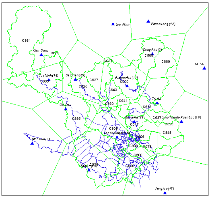
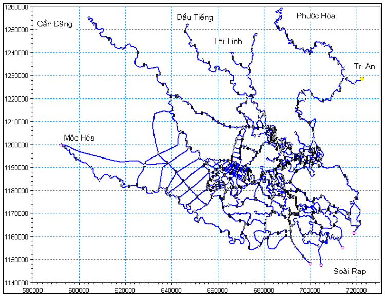
Figure 1. Distribution of downstream rainfall stations Figure 2. Schematic diagram of downstream of the
Dong Nai River system basin
Input Data
Rainfall data: Rain stations are monitored for the downstream areas of the Dong Nai River system basin using daily rainfall data. Tan Son Hoa station however is calculated using rainfall data for every 15 minutes. The frequency of rainfall is calculated according to the Gumble distribution. Under climate change conditions, rainfall during autumn is calculated corresponding to climate change scenarios (See Table 1).
Table 1. Changes in autumn rainfall (%) compared to the base period [1]
|
Scenario RCP4.5 |
Scenario RCP8.5 |
||||
|
2016 - 2035 |
2046 - 2065 |
2080 -2099 |
2016 - 2035 |
2046 - 2065 |
2080 -2099 |
|
11.4 (1.5 ÷ 21.6) |
22.6 (8.7 ÷ 38.1) |
19.7 (5.1 ÷ 34.4) |
14.0 (4.5 ÷ 23.5) |
18.4 (8.1 ÷ 29.2) |
22.0 (6.6 ÷ 37.3) |
Water level data: The water level stations for the downstream area of the Dong Nai River system basin are monitored with the hourly data. The sea level rise scenarios only consider the change in average sea level (See Table 2) according to Vietnam's climate change scenario published in 2016.
Table 2. Raising sea level (cm) based on Scenario RCP4.5 from Ke Ga Cape to Ca Mau Cape [1]
|
Timelines |
|||||||
|
2030 |
2040 |
2050 |
2060 |
2070 |
2080 |
2090 |
2100 |
|
12 (7 ÷ 18) |
17 (10 ÷ 25) |
22 (13 ÷ 32) |
28 (17 ÷ 40) |
33 (20 ÷ 49) |
40 (24 ÷ 58) |
46 (28 ÷ 67) |
53 (32 ÷ 77) |
Headwater flood data: According to the flood discharge process of the Southern Institute of Water Resources Planning during the flood control irrigation planning phase for the HCM City, future scenarios will also partially reduce flood peaks.
2.2. Model calibration
Model calibration: The model was calibrated with actual water level in 2013 at the main hydrological stations of the Dong Nai River system, then rechecked with data from 2007. Overall, the model is very good, the error of peak and bottom flood is negligible. The difference in water level between simulation and measurement is low (See Table 3).
Table 3. Parameters of October 2013 water level simulation calibration [3]
|
Station |
River |
Correlation coefficients |
Max error (%) |
|
Phu An |
Saigon |
0.987 |
0.050 |
|
Thu Dau Mot |
Saigon |
0.971 |
0.076 |
|
Nha Be |
Dong Nai |
0.987 |
-0.024 |
|
Bien Hoa |
Dong Nai |
0.980 |
0.243 |
|
Ben Luc |
Vam Co Dong |
0.987 |
-0.063 |
Model validation: Based on the set of parameters, the model correction for 2007 at the national hydrological station, including Nha Be, Phu An, Thu Dau Mot, Ben Luc was conducted. Hydraulic model validation was performed on the main river at the national hydrological stations, so the test results were relatively good. Correlation coefficients were also high from 0.971 to 0.987.
2.3. Simulation scenarios
Simulation scenarios include tidal flooding in consideration of urbanization - land subsidence and climate change in the area. The impacts of the climate change by the year of 2030 is considered according to the scenario of contribution of 10% high flood 10% tide, 10% rain under climate change and urbanization-land subsidence (2030RPC4.5) as the baseline for comparison and the scenario of contribution of 10% high flood, 10% tide, 10% rain under climate change and urbanization-land subsidence, built according to Irrigation Plan to prevent flooding in HCM City area [2] has been approved by the Prime Minister according to Decision No. 1547 (Plan 1547) (Phase 1) (2030RCP4.5_P1547). Specific scenarios are presented in Table 4.
Table 4. Simulated scenarios of the Plan 1547 [4]
|
No |
Scenario |
Rainfall (%) |
Tide (%) |
Flood (%) |
Topography |
Climate Change |
Land subsidence |
|
1 |
Present |
10 |
10 |
10 |
Not considered |
Not consi-dered |
Not consi-dered |
|
2 |
2030RCP4.5 |
10 |
10 |
10 |
Plan 2030 |
2030RPC4.5 |
Subsidence 2030 |
|
3 |
2030RCP4.5_P1547 |
10 |
10 |
10 |
Plan 2030 + Plan 1547 |
2030RPC4.5 |
Subsidence 2030 |
3. Results and discussion
1. Present and forecasted flood situation at HCM City
Present Scenario
Water levels: Water levels in the major rivers and in urban areas are rising. Those at Nha Be, Phu An, Thu Dau Mot, Bien Hoa, Ben Luc stations are 1.74, 1.78, 1.84, 2.06, 1.42 m, respectively (See Figure 3).
Flooded area: Total flooded area in the whole HCM City is 120,118 hectares, accounting for 60.5% of the total natural area. Flood depth is of 0.2 to 1.5 m depending on the area. The total flooded area in the protected area currently is 26,028 ha, accounting for 46.8% of the total calculation area (See Figure 4).
Scenario of Urbanization-land Subsidence and Climate Change Impact (2030RCP4.5)
Water level: For the scenario of 2030RCP4.5, almost all water levels in the main rivers and in the region will be rised significantly. Those at Nha Be, Phu An, Thu Dau Mot, Bien Hoa, Ben Luc stations are 1.98, 2.04, 2.19, 2.22, 1.76 m, respectively. The differences comparing to the present scenario at Nha Be, Phu An, Thu Dau Mot, Bien Hoa, Ben Luc stations are 0.24, 0.26, 0.35, 0.16, 0.34 m, respectively (See Figure 3).
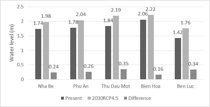
Figure 3. Water levels of the present scenario versus the scenario of 2030RCP4.5
Flooded area: The total flooded area of HCM City for the scenario of 2030RCP4.5 is about 141,758 ha, accounting for 71.5% of the natural land area and 21.641 ha higher than that of the present scenario (See Figure 4).
The total flooded area in the protected area for the scenario of 2030RCP4.5 is about 36,726 ha, accounting for about 55% of natural land area, and increase by 10,698 ha comparing with that of the present scenario. The flooded area with a depth of less than 1m, 1-2 m, more than 2 m are 20,264 ha, 14,737 ha, 1,725 ha, respectively (See Figure 6).
(3). Scenario of Urbanization-Land Subsidence, climate change impact and implementation of the Plan 1547 (2030RCP4.5_P1547)
Water levels: For the scenario of 2030RCP4.5_P1547, almost all water levels in the main rivers will increase. Those at Nha Be, Phu An, Thu Dau Mot, Bien Hoa, Ben Luc are 1.98, 2.07, 2.25, 2.23, 1.77m, respectively. The differences comparing to the scenario of 2030RCP4.5 at Nha Be, Phu An, Thu Dau Mot, Bien Hoa, Ben Luc are 0.00, 0.03, 0.06, 0.01, 0.01m, respectively. In the protected area by the flood control system in accordance with the scenario of 2030RCP4.5_P1547, the water level will be reduced by 0.87 m comparing with the scenario of 2030RCP4.5 and reach the level of +1.22 m (See Figure 5).
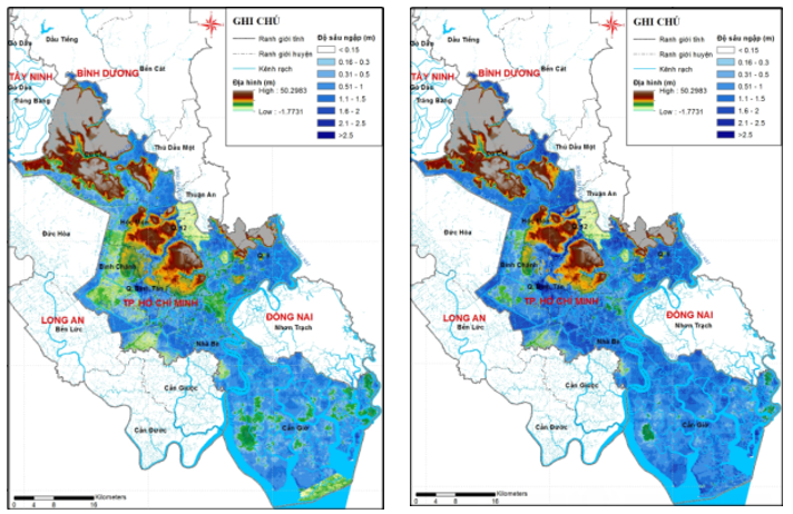
Figure 4. Flooded maps of the present scenario and the scenario of 2030RCP4.5
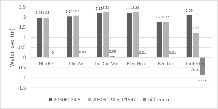
Figure 5. Projected water level according to the scenario of 2030RCP4.5_P1547 versus the scenario of 2030RCP4.5
With the scale of the first phase, instead of building 12 floodgates with protected area of about 1,800km², only 8 floodgates was built with protected area of about 1/3 comparing to the Plan 1547.
Flooded area: The total flooded area of HCM City, after the construction of flood control works is about 134,847 ha, accounting for about 68% of natural land area and decrease about 6,911 ha comparing to without those.
The total flooded area in the protected area for the scenario of 2030RCP4.5_P1547 is about 30,584 ha, accounting for about 55% of natural land area, and reduce by 6,142 ha comparing with the scenario of 2030RCP4.5. The flooded area with a depth of less than 1m, 1 - 2m, more than 2 m are 20,4184 ha, 8,685 ha, 1,482 ha, respectively. Corresponding to depths of 1 - 2m, the reduction of about 6,052 ha and the depth of over 2m, the reduction is about 243 ha comparing with the scenario of 2030RCP4.5 (See Figure 6).
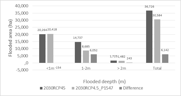
Figure 6. Simulated Flooded Area for scenarios of 2030RCP4.5 and 2030RCP4.5_P1547
Conclusion and recommendation
Flooding in HCM City is caused by heavy rain, high tide, flood discharge from upstream, urbanization-land subsidence and climate change. Predicted results show that water levels in the main rivers as well as in the urban area has been increasing significantly, resulting in increased flooded area.
When construction of 8 large floodgates and connecting them with existing dyke system to protect the central and southern regions of the city, floods under tidal impacts in the inner city will be significantly reduced. On the other hand, the water level in the main rivers outside the protected area has slightly increased in Phu An, Ben Luc, Bien Hoa stations. The dredging of canals in the central and southern regions when the tidal protection barrier was built did not have much impact on lowering urban water levels.
It is recommended that the People's Committee of HCM City soon develop an integrated strategy to minimize the impact of urbanization-land subsidence climate change on flooding in the City.
Phùng Chí Sỹ1, Phùng Anh Đức1, Phạm Thế Vinh2
1 Environmental Technology Centre
2 Southern Institute of Water Resources Research
(Source: The article was published on the Environment Magazine by English No. III/2023)
REFERENCE
[1]. Climate change and sea level rise scenarios; Ministry of Natural Resources and Environment, 2016.
[2]. Decision No. 1547/QD-TTg dated October 28th, 2008 of the Prime Minister approving irrigation planning to prevent flooding in HCM City area.
[3]. Project on "Resolving tide floods in HCM City area taking into account of climate change factor (phase 1); Southern Institute of Water Resources Research, 2015.
[4]. Phùng Chí Sỹ. Report on "Research and assessment of socio-economic impacts of climate change; develop an integrated strategy to improve flood adaptation and response capacity; Improving flood monitoring and forecasting capacity”, May 2019.