
18/09/2023
Abstract:
There are many documents related to Van Don Ancient Trading Port (ATP) system, most of which have been published by historians and archaeologists based on historical literature or excavation results, and in general a consensus has been reached. Based on reference, aggregation of existing documents, and additional investigations and surveys, following the article will analyze the perspective of natural characteristics and conditions and signs of the premise of Van Don trading port through the periods to clarify the formation, development, and decline of the Van Don ATP system. This is also the clearest evidence of the Vietnamese tradition of exploiting and using sea and islands.
Keywords: Van Don ancient trading port system, natural, geological, morphological.
JEL classification: N55, Q56, R11.
Received: 06 June 2023; Revised: 07 July 2023; Accepted: 24 July 2023.
1. Introduction
During the study on the Van Don ATP system, a question that naturally arises was whether this trading port only started operating after King Lý Anh Tông established Van Don site in 1149? Is it possible that the Van Don ATP system, or a certain part of it - its “precursor” - had previously operated? Some historical and archaeological documents seem to have confirmed this, although relatively scattered. In addition, with the comment that the Van Don ATP basically consisted of ports and wharfs on the sea, another question also automatically arises: since when has the sea existed on the Northeastern edge of Vietnam? Is it “as old as the Earth” and has it not changed since then? On the basis of existing documents and additional investigation and survey, this article attempts to give a different perspective over a longer period in association with the natural-geographical, geological-geomorphological context and characteristics, especially their fluctuations, to demonstrate the tradition of exploiting and using the sea as well as adapting to changes in the continental-oceanic interaction of the Vietnamese people, contributing to a better understanding about the values of the Van Don ATP.
2. Research methods and techniques used
- Traditional methods and techniques of the natural and social sciences have been applied such as collecting, synthesizing, analyzing, processing existing documents, sociological investigation, surveying, mapping, analyzing and processing data, and additional sample analysis...
- Specialized research methods on tectonics - geomorphology and modern research methods such as analyzing remote sensing images, building databases... have been used.
3. Research results
3.1. Geological features and context
3.1.1. Rock outcrops in the Northeast coastal region
Rocks in the Northeast coastal region, according to the results of geological investigation and research [2, 6, 7, 8, 9], are divided into several formations/series categorized into the following groups:
Group of terrigenous, metamorphic sedimentary rocks rich in aluminosilicates (sandstone, siltstone, claystone) of the formations/series Co To (S1-2ct), Tan Mai (S1-2tm), Song Cau (D1sc) (or Do Son (D1ds), Duong Dong (D1-2dd), Bai Chay (P3bc), Hon Gai (T3n-rhg), and Ha Coi (J1-2hc). They formed “soil” islands (in whole or in part) such as Tran, Co To-Thanh Lan archipelago, Vinh Thuc, Cai Chien, Van Canh, Ngoc Vung, Cong Dong, Cong Tay, Chau Diep, Tra Ban, and Quan Lan...
Group of limestone and siliceous limestone of the Trang Kenh (D2-3tk), Con Voi (C1t-vcv), Pho Han (C1t-vph)m and Bac Son formations (C-Pbs). They formed “rocky” islands mainly found in Ha Long bay and partly in the center of Bai Tu Long Bay such as Cho Island, Thien Nga Isle, Goi Isle, Tra Gioi Isle, Xep Isle, Cong Do Island, and Coc Tren Isle... (Trang Kenh formation), Cai Bau Island and many isles such as Cot, Su Tu Cai... (Con Voi formation), and islands in Ha Long Bay (Bac Son formation).
Group of Quaternary friable sediments mainly of marine origin, formed in the Holocene (11.7 Ka), including the Hai Hung formation (Q21-2hh), the Thai Binh formation (Q23tb) and the Upper Holocene sediments (Q23). They distributed in small and narrow outcrops along the sea and islands, sometimes gradually connecting clusters of islets together to form a large island as in the case of Quan Lan - Minh Chau and Ngoc Vung islands... They have created a number of depositional topographies such as coral shelves (about 1m above sea level, including exposed boulders, pebbles, gravel, coral sand, and sea shells, which are the main components of ancient beach deposit containing Cai Beo Cultural monuments dating back to about 9 - 7 Ka.), marine depository shelves (about 2m high, formed about 2.5 Ka.), low-tidal flats, high-tide flats (1 - 1.5m), modern beaches, and erosion terrain such as an abrasive shelf on bedrock (such as the one found at the edge of Cong Tay Island at an altitude of about 4 - 6m, formed about 8.2 - 4.2 Ka.).
The islands in Ha Long Bay - Bai Tu Long Bay are mainly composed of limestone, terrigenous sediments, and siliceous rocks. Limestone was mostly dissolved after being weathered, leaving only some clay impurities. In continental conditions, it can form the so-called “terra rosa” (red soil), but in the marine environment it will probably be washed or eroded away. Weathered crust and soil cover therefore rarely form in the karst islands, which makes it difficult to form thick vegetation to store both surface water and groundwater and are therefore rarely inhabited. Siliceous rocks are quite resistant to chemical weathering and are usually crushed and abraded to form sand and grit. Only the silty sand, claystone, and terrigenous rocks which are rich in both clay and sand are capable of being weathered, washed away, eroded, and accumulated... to create a substantially weathered crust, thereby resulting in a thick soil cover and thick vegetation with good capacity of retaining surface water. Therefore, there are only a few “soil” islands where humans can live.
3.1.2. Location, context and structural-tectonic features
Ha Long Bay - Bai Tu Long Bay is on the northwest edge of the Gulf of Tonkin in the Duyen Hai zone, the Eastern Vietnam fold system [2], or a part of the “Quang Ninh anticline” [9,10], occupying most of Quang Ninh Province and the Southern edge of Hai Phong City. This structure is adjacent to the “An Chau inland rift superimposed depression” in the North and the Red river - Gulf of Tonkin young subsidence area in the South.
The geological formations that make up the islands in Ha Long Bay - Bai Tu Long Bay have formed an “asymmetrical anticlinorium” with the oldest rocks (Co To formation, S1-2ct) distributed on the outermost islands (Tran Island, Co To - Thanh Lan Archipelago) and (Tan Mai formation, S1-2tm) exposed in a narrow area on Vinh Thuc and Cai Chien islands at the Northeastern edge close to the mainland. They are interwoven with younger rocks of Late Paleozoic - Mesozoic age. The anticlines of the structure are mainly made up of rocks of the Tan Mai and Co To formations. The synclines are mainly formed from rocks of the Bac Son formation.
The whole structure has a slightly arc shape, gradually changing from the Southwest (SW) - Northeast (NE) in the SW to the South Southwest (SSE) - North Northeast (NNE) at the end of the NNE, embracing the NE coast, determining the shape of the shore, the distribution direction, and the topography of the islands in this region. The gradual change of direction of the above-mentioned arc shape is probably a result of the operation of two fault systems in the NE - SW and NNE - SSW directions that have cut and shaped the islands and island clusters in this region. On that common background, some islands and island series are still dominated by basically only one fault system, either NE - SW (such as Van Vuoc - Cai Chien island series) or NNE - SSW (such as Sau Dong - Sau Nam - Cao Lo - Minh Chau -Quan Lan island series).
“Quang Ninh anticlinorium” is also divided into “Van Don monocline uplift”, “Ha Long syncline downthrow block”, and “Cat Ba anticline uplift” [10]. The boundaries between these blocks are the faults in the NW - SE, NE - SW, and sub-latitudinal directions. “Van Don monocline uplift” has a quadrilateral shape; the NE side at the NNE extreme end in Quang Ninh Province extends to Tran Island, Co To - Thanh Lan Archipelago; the SW bottom edge is a NW - SE fault zone running through the area of Cong Dong - Cong Tay, Ngoc Vung, and Phuong Hoang islands. From there back to the SW is “Ha Long syncline downthrow block” with mainly karst islands (C-Pbs) all the way to “Cat Ba anticline uplift”, including the Cat Ba islands and Do Son coastal strip, mainly composed of rocks of the Do Son formation (D1ds) and the Cat Ba formation (C1cb).
It is called “Van Don monocline uplift” because the geological units exposed here are basically increasingly younger from the outermost edge in the Southeast (Tran Island, Co To -Thanh Lan Archipelago) towards the NW, from the Co To, Do Son, Cat Ba, Bac Son, Bai Chay, Hon Gai, and Ha Coi formations until meeting the Tan Mai formation (S1-2) on a narrow outcrop on Vinh Thuc and Cai Chien islands.
A direct consequence of this structural feature, in addition to the extension of islands and island clusters and related to the formation of Van Don ATP system, is that the whole Bai Tu Long Bay is basically situated in the “Van Don monocline uplift” and is relatively shallow. Most of the seabed in the areas between the islands is only a few meters to less than 10 meters deep. Only off the coast of Quan Lan - Minh Chau Island series does the seabed’s depth gradually increase and start to exceed 30m at tens of kilometers to the East - Southeast of this island series. On that shallow seabed developed some deeper sea creeks, but most of them are just under 20m deep, rarely up to 30m deep, and basically coincide with the direction of the islands and island series, i.e., NE-SW and gradually changing to NNE - SSW
This general structure is divided and complicated by other fault systems of NW - SE, sub-longitude, or sub-latitude direction, for example, the NW - SE fault running through Cong Dong - Cong Tay area, Ngoc Vung and Phuong Hoang islands, forming Cong Dong River and Cong Yen, Cong Hep on Ngoc Vung Island. The NW - SE faults have also created a number of NW - SE creeks separating the outer barrier islands, reaching a depth of 32m between Sau Dong Isle and Sau Nam Island, 20m between Sau Nam Island and Vanh isle (Cua Sau), 22m between Vanh Isle and Ba Mun Island (Cua Noi), 20m between Ba Mun island and Quan Lan Island (Cua Doi), or in the cluster of Quyt Hoi Bac, Quyt Hoi Dong, and Quyt Hoi Nam islands... Additionally, some deep creek sections of sub-longitude and sub-latitude direction can be found in the vicinity of Cong Dong - Cong Tay Island Cluster or in the east of Ngoc Vung island.
3.1.3. Morphological and geomorphic features of islands and island shores
The karst islands in Ha Long Bay - Bai Tu Long Bay create the unique landscape of “fossil karst islands repeatedly intruded and modified by sea water”. However, most of the inhabited islands, and therefore related to Van Don ATP, are “soil islands” and exist mainly in Bai Tu Long Bay. They have low mountainous topography, mainly below 300 meter high above sea level (except for Nang Tien mountain on Tra Ban Island (450m) and Van Hoa mountain on Cai Bau Island (397m)). These islands are generally narrow and extend in the general direction from NE - SW to NNE - SSW. The slopes of the two island sides are clearly different: The Eastern slopes of Sau Nam - Ba Mun - Minh Chau - Quan Lan Island series are very steep, and the cliffs are almost vertical and close to the waterline while the western slopes are quite graded [8]. That difference is partly due to the structural features and composition of the rocks that make up the island, and partly due to modern marine dynamics. The Eastern shores of the outer barrier islands are composed of relatively straight and sloping terrigenous rock, affected by waves in four seasons, and there develop the cliff and rocky shore topographies. Particularly in the North and South of Quan Lan Island and Ngoc Vung Island, there are tombolos of early-middle Holocene age and the modern beaches. In contrast, the Western shores of the islands and the shores of the inner islands are less affected by waves than by tidal currents. Tidal accumulation forms are commonly seen, such as the tidal flats along the creek banks between Tra Ngo Lon and Tra Ngo Nho islands, the concave arc at the center of Ba Mun Island, and especially on the Northwestern side of Quan Lan Island.
At the foot of the islands, there are many muddy puddles and intertidal flats, or many narrow sandy and rocky beaches that are 30 - 70m wide and flooded by tides periodically. Some areas of hundreds of hectares have both muddy, sandy, and rocky beaches as well as deep places, beautiful landscapes, convenient for anchoring of ships and boats, such as Cai Quyt Lagoon, O Lon Lagoon, Lach Cong between Tra Ngo Lon and Tra Ngo Nho islands, and Cai De Lagoon. The most distinctive are Chuong Nep and Nhang Ria beaches in Minh Chau Commune and Son Hao beach in Quan Lan Commune. The sandy beaches in Minh Chau Commune are kilometers long and very flat and have fine white sand grains and smooth waves. In contrast, in the sandy beaches in Quan Lan Commune which are also very long and flat, the sand grains are coarser, yellow in color and the waves are stronger.
The bedrock, distributed on the islands of Sau Nam, Sau Dong, Ba Mun, Tra Ngo Nho, and the mountainous part of Tra Ngo Lon Island, is the terrigenous rock of the Do Son formation. The rest, including most of Tra Ngo Lon Island and rocky islands scattered in Bai Tu Long National Park, such as Dong Ma, Hon Chinh, Lo Ho, Mang Ha Nam, Mang Ha Bac, Di To, Chay Chay, Da Day, and Soi Nhu..., is mainly limestone. Thus, Tra Ngo Lon Island has a unique geological structure. More than one-third of the islands in the North are "soil island" on the terrigenous rock base. The rest in the south is "rock island" with karst terrain with many caves and valleys. Due to the encroachment of the sea, these valleys form lagoons in the center of the mountains, creating unique and attractive landscapes.
3.2. Marine transgression-recession events from the plate of Paleolithic period until now
Perhaps a shortcoming in the current interpretations of Van Don ATP system is that the connection with changes in the natural conditions of the area, especially the recent marine transgression-recession is not considered. Below are some of these changes:
Late Pleistocene Interglacial and Glaciation periods (130 - 11.7 Ka.): In the late Pleistocene, the Last Interglacial (130 - 110 Ka.) occurred, followed by the Last Glaciation (110 - 18 Ka.), including the Last Glacial Maximum (LGM, 26.5 - 18 Ka.). At the end of the LGM, transgression started. The sea level, which was about 120m lower than today, gradually increased (-120m approximately 18 Ka.; -20m approximately 10 Ka.). Alluvial deposition (aQ13), alluvial-marine deposition (amQ13), and marine deposition (mQ13)… were formed.
Early Holocene continent (11.7 - 8.2 Ka.): During the early Holocene, the transgression continued, forming alluvial deposition (aQ21), alluvial-marine deposition (amQ21) and marine-bog deposition (mbQ21) (the Hai Hung formation, lower part);
Middle Holocene maximum transgression (8.2 - 4.2 Ka.): The sea level rose about 4 - 6m higher than today in the first half, then maintained and lowered gradually in the second half. Middle Holocene marine deposition in the lower part (mQ22,1) and marine, alluvial-marine deposition in the upper part (amQ22,2) and (mQ22,2) (the Hai Hung formation, upper part) were formed;
Regression after the Middle Holocene maximum transgression (4.2 - 2.5 Ka.): Sea level lowered to about -4m lower than today;
Late Holocene transgression (2.5 - 1.5 Ka., ending around the 5th-6th centuries): The sea level rose to about 1.5-2m higher than today. The Thai Binh formation (Q23,2) was formed;
Regression in the latter half of late Holocene (1.5 - 0.5 Ka., ending around the 16th Century): The sea level lowered to about 1 - 2m lower than today;
Modern transgression, from about 500 years ago to the present [7].
Natural characteristics and conditions, including the changes mentioned above, will be related and explained in the following sections of the report. Moreover, the authors also support the idea that many signs and premises for the “official” formation of Van Don ATP, or in other words the “precursor” of Van Don ATP, date back to the period that is much earlier than the time King Ly Anh Tong established “Van Don site” in 1149.
3.3. Some signs and premises of Van Don ATP in prehistoric times
3.3.1. Soi Nhu Culture (about 18,000 - 7,000 years BC)
Soi Nhu Culture [3], named after the archaeological site Soi Nhu in Bai Tu Long Bay, is the prehistoric culture discovered by Vietnamese archaeologists in 1964 and excavated in 1967. Soi Nhu Culture concentrated mainly in Ha Long Bay and Bai Tu Long Bay. It is believed to be the late Late Paleolithic - Early Neolithic culture and the most ancient known in the area [3].
Typical archaeological sites of Soi Nhu Culture were found in Me Cung, Tien Ong, and Thien Long caves. They prove that the owners of Soi Nhu Culture in general lived at the same time and had the same evolutionary level as the famous Hoa Binh and Bac Son cultures and initially had signs of adaptation to the coastal life. This has added to the prehistoric picture of Vietnam with a highlight, a new basis for explaining the development path of Cai Beo culture and then Ha Long Culture - the marine cultural path for the Northeast region of Vietnam of which the main orientations were marine exploitation, including fishing as well as exchange, trading, and development of a number of handicrafts such as making pottery, stone tools, jewelry, and especially boat building [3].
3.3.2. Cai Beo Culture (7,000 - 5,000 years BC)
Cai Beo Culture was the bridge between Soi Nhu and Ha Long cultures [3]. Typical archeological sites of this culture were found in some rock shelters and caves in Ha Long bay such as Cai Beo, Ha Giat, and Giap Khau… Cai Beo Culture is depicted most typically at Cai Beo archeological site, first discovered by the French archaeologist M. Colani in 1938. A number of subsequent excavations by Vietnamese archaeologists in 1972 - 2006 identified three cultural layers, two lower layers are classified in Cai Beo Culture and the upper layer is of Ha Long Culture. The appearance of wildlife teeth and marine fish bones shows that Cai Beo people used to specialize in hunting, gathering, and fishing. In the period of Ha Long culture, residents developed cultivation and built boats to go out to the sea, more deeply adapted to the marine environment.
3.3.3. Ha Long culture (5,000 - 3,000 years BC)
In 1937 - 1938, archaeologists M. Colani (France) and G.J. Anderson (Sweden) discovered traces of prehistoric people along the shore of Ha Long Bay such as Ngoc Vung, Tuan Chau, and Cai Dam islands... So far nearly 50 monuments of “Ha Long Culture” have been discovered on the islands as well as along the coast in Ha Long bay. During that time, Ha Long ancient people lived mainly in “villages” on sand dunes, sandbanks, estuary tidal flats, and along the coast; only a few lived in caves. Stone tools and pottery are typical of the culture of Ha Long ancient people, including porous ceramics of Ha Long coast that were made from crushed mollusk shells mixed with sand and earth and decorated with wave patterns on the outside - bearing the influence of the sea. Archaeologists believe that the ancient Ha Long people must have created many means of water transportation for fishing and exchanging products with other regions. Ha Long Culture has indigenous origin and is the result of exchanges with other cultures. Ha Long culture is essentially a marine culture, one of the four prehistoric marine cultures in Vietnam [3].
3.3.4. Some signs and premises of Van Don ATP in the Northern domination period
The premises, signs, and evidence of Van Don ATP system, both in reality and in the documents, have been mentioned by many domestic and international historians and archaeologists. Recent studies, especially those of international experts on Vietnamese studies and using early Chinese written materials, show that the territory of Vietnam (Giao Chau) used to have an important position in the maritime trade routes in the East Sea [4,5].
During the Dong Son Culture period and subsequent historical periods, receiving the tradition of a dynamic and adaptable marine culture, a part of ancient Vietnamese inhabitants continued to maintain and develop their close relationship with Southeast China, but gradually expanding relations with Hainan, Taiwan, Japan, North Korea and other maritime cultures in East Asia, spreading the wet rice culture, bronze drums, tattooing, stilt-house living..., contributing to the creation of specific nuances of ancient Japanese culture. These diverse exchanges contributed to the formation of a “marine culture” which had boldly Austronesian elements and was one of the origins of Vietnamese culture [5].
Early written historical sources of China show that during at least the first three centuries of the Northern Colonial period, Giao Chau, with Long Bien prefecture, acted as a coordination center of China’s maritime trade in the East Sea, and formed a regular trade route connecting Guangzhou with the trading centers in the northwestern Gulf of Tonkin. From the middle of the third Century, the Northern Delta region could no longer maintain its position in the regional maritime trade system [4].
According to Mr. Nguyễn Văn Kim, under the rule of the Eastern Han dynasty (25 -220), the economic relationship between Giao Chau and Nam Hai region was quite developed and became prosperous in the Tang dynasty (618 - 907). As the gateway to the sea of Southern China, the Gulf of Tonkin of which the center was Van Don trading port was considered the main trade route connecting the continent with the ocean. Van Don was not only at the center of East - West exchanges but also the place of convergence of North - South relations. The author cited a number of historical sources (the book Lingwai Daida records about the reign of King Đinh Tiên Hoàng, Lê Long Đĩnh, and Lý Công Uẩn and the battles of Lý Thường Kiệt in 1075 - 1076…) showing that the main exchange activities between China and the South were conducted through the sea routes through Van Don area. The author remarked that although it was not until 1149 that the Lý dynasty established Van Don site for trading and for foreign traders’ accommodation, in fact trading activities between Dai Viet and other countries in this area must have taken place much earlier.
The monuments of Van Don ATP at Cong Ong-Cong Ba, especially the Han tombs of the Northern Colonial Period - Da Bac ancient tombs - also contribute to affirming the important position of this area even before Van Don trading port was established.
Regarding the above comment of scholars that “the northeastern sea route of our country has been studied very specifically and in detail by the Chinese”, the authors also believe that not only the Chinese but the Vietnamese people at that time also knew this sea thoroughly. They applied their knowledge not only in their daily lives but also in domestic and international trade and exchange, even in the resistance wars against foreign invaders. They certainly inherited that tradition from much earlier cultures.
4. Discussing the research results
4.1. The center of Van Don ATP system - from the perspective of natural characteristics and conditions
An interesting detail that has been mentioned by many researchers is the question of the central location of Van Don ATP. Some assume that it must be Cai Lang, others think that it must be Cong Dong-Cong Tay island cluster. According to Mr. Nguyễn Văn Kim [5], the central area of Van Don ATP consisted of 3 sub-zones. Sub-zone 1 included Cong Dong-Cong Tay island cluster that was the largest economic, cultural and diplomatic center of Van Don during the Ly-Tran dynasties. Sub-zone 2 included Hai Van island clusters which played an important role in protecting security and controlling tariffs, ensuring the handover and trade of high-class products of sub-zone 1 and at the same time enabling economic exchange activities with the outside world. From about the end of the 15th Century to early 16th Century, replacing the Cong Dong - Cong Tay area, this sub-zone gradually emerged as the largest and most important center of Van Don and continuously maintained that position until about early 18th Century. Sub-zone 3 included other wharfs in Ngoc Vung Commune, both playing the role in international trade and ensuring security in the south for the trading port. All three sub-zones combined played the most important role in political, economic, and social activities during the seven centuries of establishment and development of the ancient Van Don trading port system.
Not mentioning the second and the third zones of Van Don ATP that are outside of the present Van Don Island District, the following will further analyze the role of sub-zone 1 and sub-zone 2 of the central zone from the perspective of natural features.
First of all, both opinions are derived from an initial description mentioned in history literature “... in the sea, at the place where two mountain ranges face each other and a strip of water flows in the middle, wooden barriers are set up as a sea gate and people’s houses are built along the shore...”. The authors of this article find that both locations, Cong Dong - Cong Tay and Cai Lang - Quan Lan, appear to be suitable.
The second argument is that ceramic artifacts from the Lý – Trần dynasties and copper coins of Tang - Song - Yuan dynasties... were found in Cong Dong - Cong Tay island cluster. However, similar findings by Japanese scientist Yamamoto Tatsuro (cite in [5]) in the area of Con Quy - Cong Cai - Cai Lang wharfs show that this argument is not really persuasive. The next argument that the cultural layer in Cong Dong - Cong Tay containing artifacts of the Ly-Tran period is thicker and richer while the main cultural layer in Cai Lang - Quan Lan contains younger artifacts of the Le - Mac - Nguyen periods perhaps is not really convincing.
Another argument is that in the area of Cong Dong - Cong Tay island cluster, there are many relics of pagodas and towers... of the Tran dynasty and it was therefore more densely populated, which, in addition to vibrant trade activities, makes it more suitable as a cultural-administrative center. Next, the area has a place named Vung Huyen, which may be related to the seat of a district, and thus more appropriate for the role as an administrative center of the trading port (however, this event, if any, didn’t happen until about the 18th Century). The monuments in the Cai Lang - Quan Lan - Con Quy - Cong Cai area... are certainly ports and wharfs, but they also had the functions of outposts, inspection, supervision, customs, and taxation... However, in the following centuries, the central role of Van Don trading port was transferred to Cai Lang - Quan Lan on the grounds that a number of communal houses were built there and replaced pagodas as the place where the main cultural activities of the community took place.
According to the authors of this article, although the above analyses seem reasonable, the clear “definition of roles, functions, and tasks” as above probably does not contribute to affirming the central position of Cong Dong - Cong Tay island cluster in Van Don ATP system in this area. If other details are taken into account, such as:
Monuments of Han tombs before and at the beginning of the first Century AD on Cai Ban Island, Da Bac Village, Minh Chau Commune;
Lý Thường Kiệt’s military campaigns along Dong Kenh River in 1075 - 1076 against the Song invaders;
The fact that King Lý Anh Tông set up Van Don site in 1149 could only happen in relation to Van mountain, Van garrison... on Van Hai Iisland cluster;
The victory of Van Don on Mang River of Trần Khánh Dư in 1288... then Mang River and the monuments along it seem to have been known earlier and used for more diverse activities than on Cong Dong-Cong Tay island cluster.
Furthermore, back to the original description of the trading port’s location on “...set up wooden barriers as a sea gate...”, a natural question is that if those barriers had not been set up there for customs, border guards, taxation... then what would have been their roles? If so, would the location on Mang River have been more appropriate? Given the foregoing, the authors argue that it may not be so important to find a single location with the central role of Van Don ATP system as well as to argue about the shift of that center from time to time. Given the distance between two places - Cong Dong - Cong Tay and Cai Lang - Quan Lan -Cong Cai - Con Quy... - was not too far from each other and traveling was not too difficult, considering both places as the center of the ATP system is not too unreasonable.
For the monuments on Van Hai island cluster (Cong Don, Cai Cong, Con Quy, Cong Cai, Cai Lang, and Quan Lan...), some observations below from a geological-geomorphic perspective can contribute to explain why the ancient people chose this area as a trading port:
The development of a fault zone in the NNE - SSW direction along which the Mang river lies and flows depending on the tide and the large space were probably suitable for building an outpost here for military and immigration control, even for setting up a “site” for population gathering, trading and foreign traders’ temporary residence;
The fact that terrigenous rocks created soil, enabling the formation of thick vegetation, storing fresh water, and at the same time storing groundwater in cracks, fracture zones... is clearly one of the most important criteria. A range of freshwater wells scattered on both banks of Mang River proves this statement;
Van Hai Island cluster along the Eastern edge helps to shield all ports and wharfs in this area from winds and storms. Similarly, the intersection between different fault systems and fault zones also facilitated the formation here of land-locked lagoons, which are convenient for mooring boats and ships;
At first, perhaps the area that is now the center of Quan Lan Island Commune, even the tombolos connecting Minh Chau - Quan Lan islands, did not exist. Cai Lang wharf faced small islands scattered in all three directions, creating a relatively closed lagoon to the south convenient for boats to anchor. Only a few centuries later, due to sedimentation, Cai Lang wharf became shallow while the tombolos made Quan Lan gradually larger and more attractive for development activities;
If the sea level was about 1.0-1.5m lower than today when King Lý Anh Tông established Van Don site in 1149, then the factors of current, tide, width of Mang river, and distance between the islands... were even more favorable for the development of ports and wharfs in this area...
Similarly, for the area of Cong Dong-Cong Tay islands, the following comments from a geological-geological perspective can help explain why the ancients chose this area to build wharfs, headquarters, and places to practice religious rites:
The development of a NW - SE fault has split the two islands Cong Dong - Cong Tay and widened the northern end of Cong Dong Iisland. The fault itself has also deeply penetrated into the bedrock, enabling sea water to flow in to form Cong Dong River (or Thua Cong River)-sea creek which was deepest in the middle (up to nearly 10m) and gradually shallower towards two ends (only about 5 - 6m). This sea creek and Cong Dong - Cong Tay islands themselves were also further divided by a system of faults and small rupture zones in the NE - SW direction, creating a series of small sea lagoons deeply encroaching in the two islands. The position of the two islands also contributes to screening off winds and storms... These characteristics combined made Cong Dong - Cong Tay Island cluster an ideal port system for ships and boats;
Sandstone, siltstone, and claystone, the main composition of the Duong Dong formation, have weathered into a thick layer of soil, facilitated a good vegetation cover and helped to retain rainwater, surface water, and groundwater, which is a prerequisite for people to live and also the most important factor for ships to stop by to replenish water on voyages of weeks and months long. Of the thousands of islands in Ha Long Bay - Bai Tu Long Bay, most are karst islands, only a few are “soil” islands. Thang Loi Commune also has hundreds of islands but only about a dozen soil islands and the two islands Cong Dong -Cong Tay are the only places inhabited because of this factor;
The maximum Middle Holocene transgression (about 8.2 - 4.2 Ka.) left on the two islands a flat abrasive terrace at an altitude of about 5 - 6m, which was also a favorable condition for the construction of houses and human works;
The intersection between the above-mentioned NW-SE and NE-SW fault systems also contributed to the creation of a number of relatively flat expanses which were later exploited by humans. Places with high terrain and good feng shui (for example, leaning against the mountain, streams on both sides to provide water, not being affected by natural disasters…) were used for building pagodas or towers while places with low terrain close to the sea were suitable for making wharfs for ships to anchor. Other locations (for example, on the north side of Cong Dong Island) where mud and sand accumulated, were renovated by ancient peoples to make rice fields...;
Some locations with exposed bedrock along the shore or near the middle of the creek were used by the ancients to make wharfs, load and unload, and gather goods...;
In general, Cong Dong - Cong Tay Island cluster was almost in the center of the coastal-island zone of Bai Tu Long bay in particular and the northeastern sea in general, at the sea crossroads between the international seaport Hon Net and Cua Ong Port and coastal inland waterways. It was an ideal location to go to Minh Chau - Quan Lan, and Ngoc Vung Island communes and further to Co To Island District - Tran Island, or to large coastal ports in Cai Rong Town, Cam Pha City, and Ha Long City;
Similarly, if the sea level in this area in 1149 was about 1.0 - 1.5m lower than it is now, then Cong Dong River might be even narrower; the wharf positions may even be completely exposed on the water surface, the travelling between the two islands, the anchoring of boats, the concentration of population, and the practice of religious and administrative rituals... could be much easier than today...;
Last but not least, the above-mentioned features along with the 20 - 30m deep sea creeks around Cong Dong - Cong Tay Island cluster and its vicinity may have been the main natural elements that contributed to determining the location of Hon Net international seaport.
4.2. Influence of natural conditions on the tradition of fishing and using sea of the Vietnamese and the decline of Van Don trading port system
Along with the establishment and development of Van Don ATP system, its decline was also mentioned by the same researchers mentioned above [4, 5] almost from political-economic-social aspects. The question is whether natural features and conditions, or more precisely, their fluctuations and changes, had any role in the decline of Van Don trading port system. The section below attempts to identify the effect of natural geographical-geological conditions on the tradition of exploiting and using the sea of Vietnamese people in general and the decline of Van Don trading port system in particular.
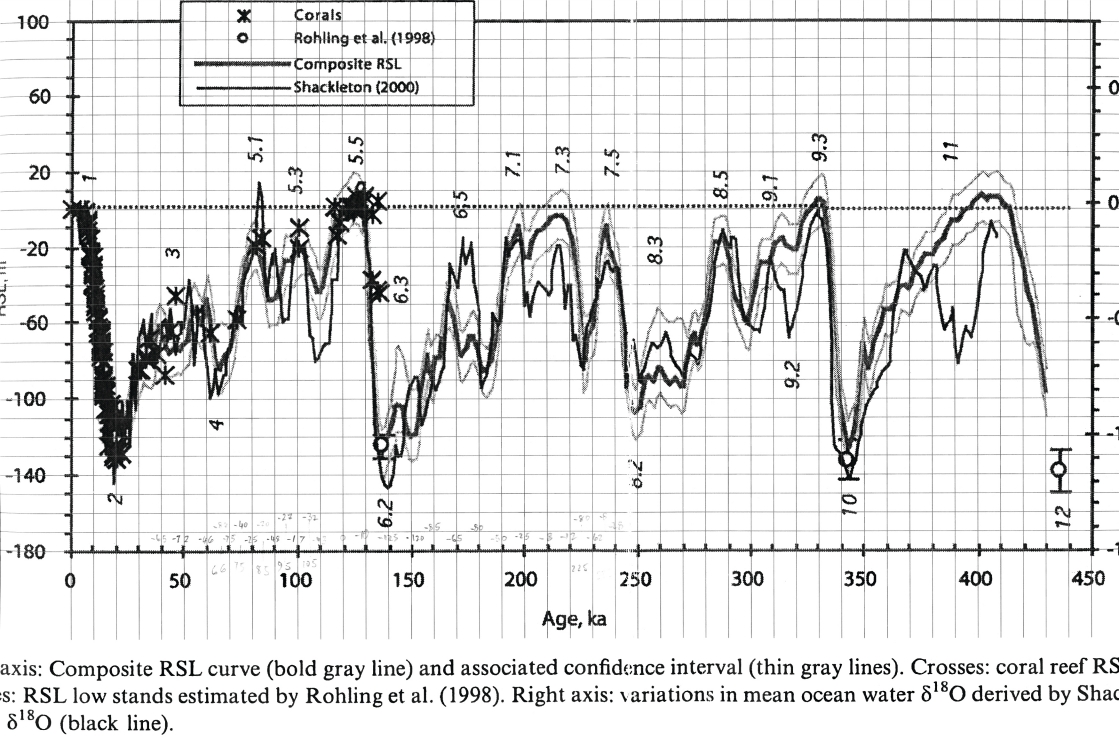
*Figure 1. Comparison of relative sea level (RSL) fluctuations estimated by Rohling et al. (1998) [6] (left vertical axis, unit: meter (strong black line), and confidence intervals (thin gray line)) with mean oxygen-18 (d18O) isotope variation in seawater (right vertical axis) calculated by Shackleton (2000) [cited in 6] about 450 Ka. BP. Multipliers represent relative sea levels defined from coral reefs. The small circles represent low sea levels estimated by Rohling et al. The dotted line is the current sea level.
In the structural - tectonic context of the northeastern coastal region as a part of the Dong Trieu arc as mentioned above, entering the neo-tectonic stage (about 65 Ma. up to now), the block lifting and lowering activities, erosion, outwash, accumulation... have begun to shape today’s scene. Particularly, the formation of the East Sea subsided depression started from about 32 Ma. contributed to the formation of coastal structural depressions, later together with other exogenous processes forming a system of islands and creeks along the northeastern coast. However, the landscape as we see it today was mainly shaped in the continental context before being invaded and transformed by the sea many times. The islands were formerly the tops of mountain ranges and mountain blocks while the sea creeks were formerly crevices, canyons, and tectonic valleys between mountains, ancient flows.... Most of them also were developed in the general structural direction of the area. The “monocline uplift” structure has contributed to the formation of “soil islands” on the easternmost edge and most of the “rocky islands” in the center of Ha Long Bay - Bai Tu Long Bay now.
In the past, many transgressions-recession events have occurred. In Figure 1, data on relative sea level (RSL) [6] is aggregated and compared. The results show that the sea level rose and fell many times during that period but rarely exceeded the current sea level. However, the most interesting part of the chart is the sea level fluctuations from about 20 Ka. BP, i.e. late Pleistocene-Holocene, corresponding to the late Paleolithic and the entire Neolithic.
In the part below, the sea level fluctuations (regardless of modern tectonic movements) of this period are mapped with prehistoric cultures in the northeastern coastal strip of Vietnam as well as other changes in the political, economic, social and cultural life of Dai Viet in general and Van Don ATP in particular.
About 11.7 Ka the sea level was about 60 - 50m lower than today. The Soi Nhu Culture (20 - 9 Ka.) coincided with the end of the Last Glacial Maximum and the beginning of the transgression. The mean rate of rising water was about 10mm/year, from about -120m (18 Ka) passing -60m to -50m (11.7 Ka) then up -30m (9 Ka). At the end of the Soi Nhu Culture (about 10-9 Ka.), the Gulf of Tonkin was shallow and ramp, the coastline was only about 10-20km from the mainland. It was entirely possible to forage from the sea and sea began to have some certain influence on this culture; however, the possibility that prehistoric people at that time in this area followed the sea to Japan as hypothesized by Wilhelm G. Solheim above) is remote. It is more likely that prehistoric humans in the islands in Southeast Asia did that.
Middle Holocene transgression continued in the period 9 - 7 Ka at the same time with Cai Beo culture. Sea level continued to rise from about -30m to -10m. Sea water came close to Quan Lan - Minh Chau islands, forming a shallow lagoon between these islands and Co To - Tran Island cluster, turning them into an archipelago. The strip from Quan Lan -Minh Chau islands to Cai Rong was basically mainland. In the south, in the present-day Cat Ba-Do Son island area, the sea also encroached and flooded the bay between these two places. However, in general, the landscape of Ha Long Bay - Bai Tu Long Bay at that time was probably similar to that of Hoa Binh and Bac Son areas now with karst towers and cones rising above the valleys and corrosive plains... Some small creeks in Bai Tu Long Bay today are at a depth of >-10m, even up to -30m, but perhaps then they were only inland flows; Mang River was just a river (maybe even just two streams flowing in opposite directions from the area of Con Dam, Con Sang, and Soi Sat Isle). But with the sea encroaching close to Quan Lan - Minh Chau islands, about 10km from the mainland (Cai Rong Town), sea element become much bolder in Cai Beo Culture.
Ha Long culture (5 - 3.5 Ka.) existed at the right time when, and right after the Middle Holocene transgression reached its maximum (8.2 - 4.2 Ka.), remained at about 4 - 6m higher than today and began to lower. In the first half of this period (8.2-5.5 Ka.), the sea level rose from a depth of about -10m to about 6m higher than today. The part above the water of the islands/island clusters became smaller, the lagoons became deeper, and Mang river became a creek that was wider and deeper than it is now. In the south, the transgression flooded the area that is now Hai Phong and its surroundings. The coastline was the widest in the Holocene, and prehistoric humans had to move inland. In the second half (5.5 - 4.2 Ka), sea level began to lower at a rate of about 5.5 - 5.0mm/year. At the end of Ha Long culture, it was still about 1.5m higher than today. Sea level continued to drop at the rate mentioned above until about 2.5 Ka. to a depth of about 4m lower than today. Despite the fluctuations, the sea remained with the northeastern coast although it was shallower, and the surface area was smaller than today. On the common background of the shallow sea, a system of relatively deeper sea creeks formed and developed in the general structural direction of the area and some estuaries. Mang River sea creek again became a river (or two small streams flowing in opposite directions). Combined with the system of outermost island series that acted as a shield against storms, these factors made coastal navigation in this area relatively convenient. Not to mention that the processes of transportation and sedimentation of sand in that context also resulted in tombolo - sand dunes connecting islands - causing some clusters of small islands to gradually combine to become larger islands more convenient to life (for example, Ngoc Vung and Quan Lan islands mentioned above). Thanks to those favorable factors, the prehistoric people and later the Vietnamese people adapted to the sea, conquered new lands, and began to develop a true marine culture. The “precursor” parts of Van Don ATP system probably started there or at least 2,500 years before this system was officially formed in 1149.
About 2.5 - 1.5 Ka. (about 500 BC to the 5 - 6th centuries) corresponding to the late Holocene transgression, the sea level rose about 1.5 - 2m higher than today, the speed was about 6mm/year. About 1.5 - 0.5 Ka. (from the 5 - 6th to the 15 - 16th centuries) corresponding to the regression in the second half of late Holocene, the sea level was lower than today by about 1 - 2m, the speed was about 4mm/year. In the south, Bach Dang estuary existed as a delta estuary, accreting rapidly both in the Northeast and Southwest of Do Son. Since then, it has been the modern transgression with sea level rising at a rate of about 3mm/year. Despite such sea level fluctuation, the sea stayed in the Ha Long Bay - Bai Tu Long Bay area. Mang River once again became a sea creek. In the area of Bach Dang estuary, about 700 - 500 years ago, although the sea level was still rising, alluvial deposits still prevailed. From about 500 years ago until now, transgressions here have become dominant, causing erosion. The ancient Vietnamese were used to the sea and no longer had to move inwards when the sea level rose, and marine culture played the dominant role in their lives in the northern coastal region. In that context, the Tran family, belonging to the Bach Viet ethnic group living in the land of Min (Fujian, China), migrated south from 227 BC. After 700 years of living in Kinh Bac, the Trần family was divided into many branches, but in the primary line, Tran Tu Vien (582 - 637) emerged as a great talent of Giao Chau. The Tran family settled down and developed, even founded the Truc Lam Yen Tu Zen Lineage, and ended. All these events occurred in the regression context with new lands explored, but the sea has become an indispensable and integral part of Dai Viet in general and the Dong Trieu arc river and mountain system in particular.
Regarding the declined role of Van Don ATP system and the possible impacts of natural geographical-geological conditions, through investigation, survey and research, the authors basically did not find any features or conditions that were too negative in the Northeast coast. It is evidenced by the fact that the large deep-water ports, both international and domestic, such as Cai Lan, in the former Cua Luc area, and Hon Net, in the vicinity of the Cong Dong - Cong Tay Island cluster, have been and are still being developed. However, there is a natural factor outside the distribution range of the ancient Van Don trading port system that may have had a significant influence - the deterioration of the Duong - Kinh Thay - Bach Dang River system which was gradually replaced by Red Rriver. The flow tended to gradually shift to the Southeast to finally reach the current location of Ba Lat estuary. That is also the reason for the gradual decline of other trading ports in Duong Kinh and Tien Lang (Hai Phong). The authorities of other trading ports such as Hai Phong and Cat Hai (Hai Phong City) have been spending considerable expenses for dredging and stream regulation to ensure smooth operation. To some respects, it indicates the natural degradation of the Duong - Kinh Thay - Bach Dang River system as well as the Thai Binh River system in this area.
5. Conclusions
The formation and development of Van Don ATP system, officially from 1149 to the beginning of the 18th Century, especially under the Lý - Trần dynasties, and unofficially in the form of “precursory” parts of the system at least 2,500 years ago, are the clearest evidence of the tradition of exploiting and using the sea of Vietnamese people. The elements of “marine culture” began to appear from the last stage of Soi Nhu Culture, grew stronger in Cai Beo Culture, became “true” in Ha Long Culture, and were further promoted in Dong Son cultures, throughout the Northern Colonial period and especially since Dai Viet became an independent sovereign state. The Vietnamese in ancient time and up to the modern period proved to be very knowledgeable about natural features and conditions, especially the geographical-geological characteristics and conditions of the “Dong Trieu arc” in the interaction with the sea and its variation cycles and know how to take advantage of this knowledge in all aspects of life, including maritime trading activities, both domestic and international.
The natural features and factors of the northeastern coastal region did not play a significant role in the decline of Van Don ATP system. In contrast, that role was taken over by the fluctuations in the Red river - Thai Binh river system in relation to the operations of the Red River subsided depression and the Red river deep fault. This issue will be further elucidated in the following articles on the Vietnamese tradition of using rivers and water.
Trần Tân Văn, Đỗ Thị Yến Ngọc, Cao Thị Hương, Hoàng Xuân Đức,
Đoàn Thế Anh, Đoàn Thị Ngọc Huyền, Nguyễn Đình Tuấn
Center on Karst and Geoheritage
Vietnam Institute of Geosciences and Mineral Resources
(Source: The article was published on the Environment Magazine by English No. II/2023)
Acknowledgments: This article was implemented in the framework of the task the project: "Research on geological-geomorphological and biodiversity characteristics and values of the Yen Tu Complex of Monuments and Landscapes", funded by the Quang Ninh Province Department of Science and Technology and implemented by the Vietnam Center on Karst and Geoheritage (Vietnam Institute of Geosciences and Mineral Resources).
References
Do Van Ninh, 2004. Thương cảng Vân Đồn (Van Don trading port), Thanh Nien Publishing House, Hanoi. pp. 133, 143.
Dovjikov A.E. (Editor), Bui Phu My, Vassilevskaja E.D et al., 1965. Geology of North Vietnam. pp. 584., Vietnamese translation, Science and Technics Publishing House, Hanoi.
Ha Huu Nga. Soi Nhụ - Nền văn hóa cổ nhất hiện biết trên Vịnh Hạ Long (Soi Nhu - The oldest known culture on Ha Long bay). Proceedings of the Ha Long Bay - 5 years of World Heritage Conference. Ha Long city, April 2000.
Hoang Anh Tuan, 2008. Vị trí của Việt Nam trong hệ thống thương mại Biển Đông thời cổ trung đại. (Vietnam’s position in the ancient and medieval East Sea trading system.) Proceedings of the third international conference on Vietnamese studies (Hanoi, December 2008). Journal of Historical Research No. 9-10/2008, pp.1-16.
Nguyen Van Kim. Vân Đồn - Thương cảng quốc tế của Việt Nam (Van Don - Vietnam’s international trading port), Hanoi National University Publishing House, 2014, 2016.
Rohling, E., Fenton, M., Jorissen, F. et al., 1998. Magnitudes of sea-level lowstands of the past 500,000 years. Nature 394, 162-165 (1998). https://doi.org/10.1038/28134.
Tran Tan Van, Do Thi Yen Ngoc, Nguyen Xuan Nam et al., 2022. Report of the Quang Ninh Provincial Science and Technology project “Nghiên cứu các đặc điểm, giá trị địa chất-địa mạo và đa dạng sinh học Quần thể di tích và danh thắng Yên Tử” (“Study on the characteristics, values of geology-geomorphology and biodiversity of The Complex of Yen Tu Monuments and Landscapes” (2021-2023). VIGMR
Tran Tan Van, Pham Kha Tuy, Do Thi Yen Ngoc et al., 2010. Điều tra nghiên cứu các di sản địa chất và đề xuất xây dựng công viên địa chất ở miền Bắc Việt Nam (Investigate and research geological heritages and propose to build a geopark in the North of Vietnam). Summary report of State-level science and technology project code KC.08.20/06-10. Archives Ministry of Science and Technology.
Tran Van Tri et al., 1977. Địa chất Việt Nam, phần Miền Bắc (Geology of Vietnam, Northern part). Science and Technics Publishing House, Hanoi.
Tran Van Tri and Vu Khuc (Editor), 2009. Địa chất và tài nguyên Việt Nam. (Geology and resources of Vietnam). Publishing House for Science and Technology. Hanoi. pp. 589.