
19/04/2024
Abstract
In recent years, Vietnam has undergone rapid urbanization, resulting in a significant expansion of urban land to cater to the escalating housing demands of its population. This trend is expected to persist in the foreseeable future. However, the outcomes of implementing urban land planning and usage strategies have revealed several shortcomings and constraints in management, utilization, demand forecasting, policy formulation, and enforcement, particularly concerning soil classification. The primary cause lies in the absence of specific regulatory provisions within existing laws governing norms, criteria, spatial delineation, land use zoning, and preservation of natural ecosystems during the planning process across all administrative levels. Based on data analysis methods applied to the experiences of the Federal Republic of Germany, China, and Japan in urban land use planning and management, it becomes evident that future urban land planning must integrate considerations of space, land use zoning, and natural ecosystems. This necessitates a clear delineation of protection and conservation criteria, coupled with a robust implementation process. Effective execution of these measures will significantly enhance the quality of urban areas and advance the objectives of sustainable urban development. Consequently, the article presents policy recommendations tailored to Vietnam's context for urban land management and utilization during the preparation and adjustment of land use plans.
Keywords: Land use planning, urban land, land use zoning, natural ecosystem
JEL Classification: K11, Q15, R15
Received: 1st February 2024; Revised: 3rd March 2024; Accepted: 25th March 2024
1. INTRODUCTION
Urbanization is a global trend, most urban areas across the country have demonstrated their role as important driving forces in economic growth and development. In Vietnam, according to data from the Department of Urban Development, Ministry of Construction, Vietnam currently has 888 urban areas, the urbanization rate reaches 41.5% and the target is to increase to 45% by 2025 and above 50% in 2030. The process of urban expansion always goes hand in hand with the conversion of land use purposes and structures in cities, which poses requirements for planning in general and land use planning in particular. Resolution 18-NQ/TW proposed solutions to innovate and improve the quality of land use planning, which is "land use planning must combine criteria of land types associated with space, land use zoning, natural ecosystems...". The establishment of urban land use planning serves as the cornerstone for guiding and advancing the urbanization process towards sustainable development, balancing economic prosperity with ecological well-being. This article aims to emphasize the current situation, international experiences in the management and utilization of urban land, concerning spatial organization, land use zoning, and the conservation of natural ecosystems.
2. THE CURRENT SITUATION OF URBAN LAND MANAGEMENT IN VIETNAM
According to a report released by the Ministry of Natural Resources and Environment, by December 31, 2020, the entirety of the nation possessed 2,028.07 thousand hectares of urban land. This urban land encompasses all categories of land situated within the administrative perimeters of wards and towns, as well as new urban areas delineated within the developmental plans of districts, towns, and provincial cities endorsed by competent authorities. This urban land constitutes 6.12% of the overall natural land area.
Table 1. Some land use indicators in urban land in 2020
|
TT |
Land type |
Unit |
Total |
Northern midlands and mountains |
Red river delta |
North Central and Coast |
The Central Highlands |
The South East |
The Mekong Delta |
|---|---|---|---|---|---|---|---|---|---|
|
I |
Total urban construction land area |
Thousand hectares |
663.79 |
69.25 |
153.99 |
160.08 |
45.63 |
143.41 |
91.43 |
|
|
Average per urban population |
m 2 /person |
200.40 |
303,34 |
194.81 |
279.84 |
272.27 |
128.08 |
210.57 |
|
1 |
Land in urban areas |
Thousand hectares |
190.29 |
19.52 |
37.87 |
43.07 |
14.72 |
47.54 |
27.57 |
|
|
Average per urban population |
m 2 /person |
57.45 |
85.51 |
47.91 |
75.29 |
87.84 |
42,46 |
63.50 |
|
2 |
Specialized land |
Thousand hectares |
376.86 |
40.01 |
98.00 |
92.81 |
26.38 |
80.16 |
39.49 |
|
|
Average per urban population |
m 2 /person |
113.78 |
175.28 |
123.98 |
162.25 |
157.39 |
71.59 |
90.95 |
|
II |
Agricultural land and unused land |
Thousand hectares |
1,364.28 |
279.09 |
175.54 |
345.58 |
199.25 |
131.28 |
233.54 |
Source: Resolution No.39/2021/QH15 of the National Assembly
In the period 2011 - 2020, there was a notable expansion in urban land area by 510.92 thousand hectares, averaging an annual increase of 51.09 thousand hectares, thereby fostering the development of a well-distributed urban network system across the nation's territories. This growth has been conducive to advancing the processes of industrialization and modernization. The average urban land per capita nationwide stands at 530 square meters, although significant regional disparities exist: the Central Highlands region boasts 1,137 square meters per person, the Northern Midlands and Mountains region 1,136 square meters per person, the Mekong Delta region 720 square meters per person, the North Central and Central Coast regions 689 square meters per person, the Red River Delta region 422 square meters per person, and the Southeast region 197 square meters per person.
In terms of socio-economic regions, there is a relatively balanced distribution of urban land: the Northern Midlands and Mountains region encompasses 348.34 thousand hectares, the Red River Delta region comprises 329.53 thousand hectares, the North Central region encompasses 329.53 thousand hectares, the Central Coast region contains 505.66 thousand hectares, the Central Highlands region spans 244.88 thousand hectares, the Southeast region encompasses 274.69 thousand hectares, and the Mekong Delta region covers 324.97 thousand hectares (structured data for each region is presented in figure 1).
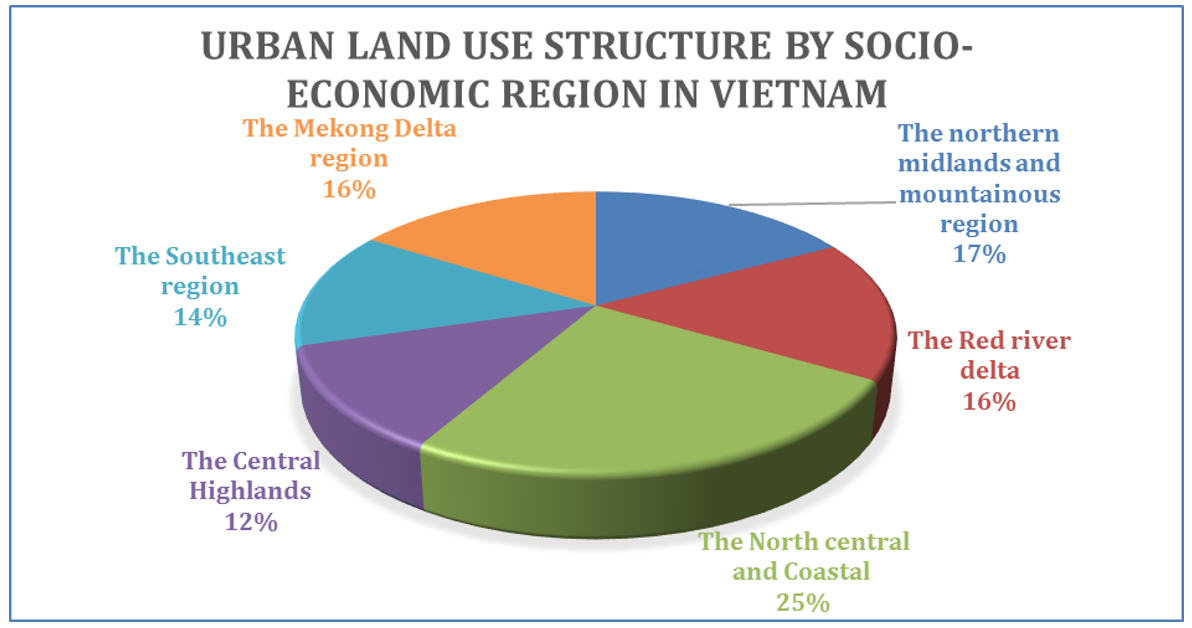
Figure 1: Urban land use structure by socio-economic region
Investment focus on urban infrastructure, particularly in major cities, has been notable. Numerous key projects such as main arterial routes leading into and out of urban centers, radial traffic axes, urban bypasses, ring roads, significant bridges, and intersections have been undertaken and completed. Efforts in water supply, drainage, and solid waste management have yielded initial successes. Overall, the urban construction land area of the country has expanded rapidly, reaching 1.25 times the size in 2010, with a per capita allocation of 200 square meters, surpassing the 2010 target by 1.07 times, essentially fulfilling the requirement for average urban land area per person in a modern city. However, the substantial increase in urban land has been primarily driven by administrative decisions and has outpaced the pace necessitated by economic development.
Concerning the structure of urban construction land usage, the proportion allocated to infrastructure construction remains relatively low, accounting for approximately 31.14% of total construction land, particularly with transportation occupying only about 16% of urban areas (below the desired ratio of 20 - 25%), while static traffic occupies less than 1% (falling short of the minimum requirement of 3 - 3.5% of urban construction land area). Additionally, the land set aside for water supply, drainage facilities, and green spaces is insufficient compared to prescribed standards. Moreover, the reduction of water surface areas (ponds and lakes) in many urban regions due to land leveling for housing construction has been observed. Furthermore, the allocated land for recreational areas and other public amenities is inadequate, failing to meet the needs of the populace.
The per capita residential land allocation in urban areas varies significantly across regions and localities nationwide. The utilization of residential land remains inefficient and uneconomical, primarily featuring divided lots, townhouses, and tube houses, with a low proportion of high-rise apartment buildings. Moreover, the construction of housing for low-income individuals in major urban centers falls short of requirements.
3. INTERNATIONAL EXPERIENCES IN URBAN LAND USE PLANNING
According to estimates by the United Nations, there are about 4.2 billion people in the world (accounting for more than 55% of the population) living in cities. Over the next 30 years, the global urban population could grow to about 3 billion people, meaning the proportion of people living in cities will reach nearly 70% by 2050. The continual expansion in urban area, scale, and population, alongside global challenges such as climate change, economic instability, food security, and the COVID-19 pandemic, imposes demands on urban planning, particularly in urban land use planning, to effectively address the complexities arising from the process of urbanization. Many countries worldwide have introduced novel ideas and innovative strategies in urban land use planning and management to tackle social, economic, and environmental issues, aiming to optimize the urbanization process. A comprehensive approach to resource management within a long-term strategy is seen as the most effective means to promote sustainability.
In Germany, urban planning operates across five hierarchical levels, corresponding to the authority of each administrative unit: the National Spatial Development Plan (at the Federal level), Regional Planning, Sub-regional Planning (at the State level or "Länder"), and municipal-level City Master Planning and City Detailed Planning. The Federal Spatial Development Plan pertains to the integrated, inter-regional, and inter-sectoral development of the entire territory of the Federal Republic of Germany. While the Federal Government is responsible for defining the fundamental principles and models for spatial development nationwide, as well as establishing a framework of substantive and procedural regulations through the Federal Spatial Planning Act, the States are tasked with completing, further regulating, and implementing these directives.
As per the Federal Building Code, the core concept of urban land use planning revolves around "sustainable urban and spatial development," considering economic, social, and ecological factors within an area. In terms of authority, the enactment of urban policies and urban planning is the prerogative of each city government, granting cities independence in their planning endeavors. However, German law mandates that municipalities must prepare urban land use planning (Bauleitpläne) in instances where organizing and developing urban areas are deemed necessary. Although the State government delegates autonomy to cities in formulating and coordinating urban planning and urban land use planning, it is imperative that these initiatives align with the principles endorsed by the government. Urban land planning and management revolve around three distinct categories of areas or regions: white land areas (Außenbereich), areas designated for construction permits (Innenbereich), and areas subject to legally binding land use planning. White lands are zones where construction is prohibited, typically reserved for non-urban activities, serving the purpose of maintaining ecological equilibrium. Continuous construction areas permit development and construction without the necessity of adhering to legally binding land use planning. The remainder of the city, excluding the aforementioned zones, must undergo planning according to urban land use guidelines and align with spatial planning objectives outlined in regional planning regulations. By delineating land use into these three zones, cities not only ensure appropriate land utilization and prevent disruptions to ongoing land plots and projects but also foster ecological balance, aligning with the sustainable development objectives advocated by Germany and other European nations. An exemplification of land use classification in urban land use zoning within the city of Münster, Germany, will be presented in Figure 2.
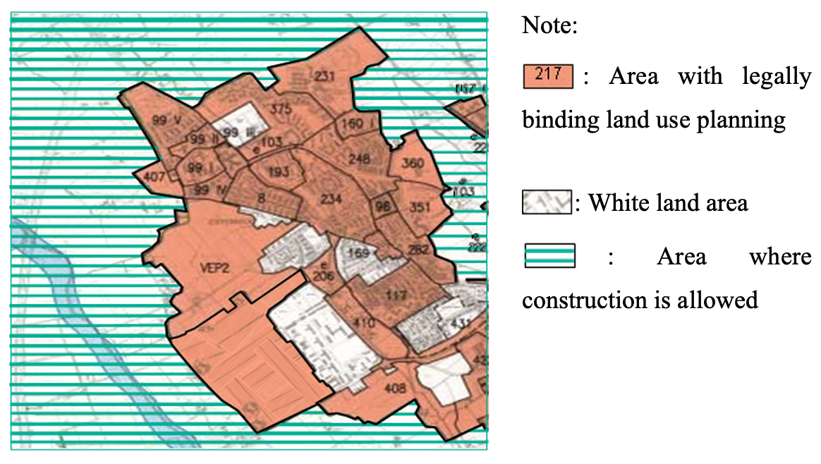
Figure 2. Urban land use zoning in Münster city, Germany
Source: Urban Development and Urban Policy in Germany - An Overview (2000).
In Asia, China and Japan are considered two countries with strict, modern urban planning and management policies, setting examples for other developing countries. China, in particular, boasts two significant national-level policies that play a pivotal role in advancing strategies related to green spaces and urban housing: the Land Management Law of the People's Republic of China and the standards for urban land use classification and development land planning (Junfang Xie et al., 2021). Forecasts by both domestic and international organizations indicate that over half of China's population will reside in urban areas by 2050. This projection places pressure on ensuring a judicious allocation of land resources, while also prioritizing environmental conservation and the well-being of citizens. The Land Management Law of 2004 enshrined the provision that "Individuals have the entitlement to demand that governments at all administrative levels enforce synchronized planning and stringent management measures to safeguard and enhance land resources, preventing unlawful appropriation and misuse of land" (Chapter 1, Article 3). This policy guarantees that planning, both in a general context and specifically in land planning, must be established upon the foundation of the nation's socioeconomic development potential, rational resource utilization, and environmental preservation.
Continuing this perspective, the Urban and Rural Planning Law mandates that city-level comprehensive planning must adhere to the following principles:
• Strict protection of farmland and keeping land for agriculture under control lest it should be occupied and used for non-agricultural construction;
• Increasing the land utilisation ratio by;
• Making overall plans for the use of land for different purposes and in different areas;
• Protecting and improving ecological environment and guaranteeing the sustainable use of land; and
• Maintaining a balance between the area of cultivated land used for other purposes and the area of land developed and reclaimed.
Table 2. Permitted ranges of per capita area and the percentages of urban land allocated for different uses
|
Category of urban land-use |
m2 /person |
Proportion in 1990 (%) |
Proportion in 2010 (%) |
|
Residential use |
18.0~28.0 |
20~32 |
25~40 |
|
Industrial use |
10.0~25.0 |
15~25 |
15~30 |
|
Streets and transportation |
7.0~15.0 |
8~15 |
10~25 |
|
Green space |
≥9.0 |
8~15 |
10~15 |
|
Administration and services |
≥5.5 |
|
5.0~15 |
In accordance with the aforementioned standards and regulations, China has introduced a comprehensive set of green urban criteria and national green urban standards aimed at promoting widespread adoption of large-scale modern, environmentally friendly urban development projects nationwide. These standards serve as a model for fostering ecologically sound urban landscapes. Key indicators for green urban areas include per capita average public green space, green land coverage ratio, and green tree coverage ratio, with variations tailored to accommodate environmental and climatic disparities between southern and northern regions of China.
To advance sustainable development objectives, the "National Garden City" initiative has been implemented to prioritize ecological considerations within the urban planning process. This model, endorsed by the Chinese Central Government, integrates the preservation of cultural heritage with the establishment of a robust green space system, thereby advancing the overarching development objective of "constructing civilized and modern cities" in the 21st century. Key goals for the national garden city scheme was to ensure that the percentage of green spaces in urban areas should be higher than 36% and have potential opportunities to achieve more than 40% in the future. This national standard guide also established a value assessment which gives the indicator to measure the quality of green space, as well as the indicator to measure functional assessment, cultural value assessment, wildlife assessment and conservation of diversity in city
Table 3. Main indicators for “National Garden City” in China
|
Basic indicators |
|||||
|
City indicators |
Large |
Medium |
Small |
Location of the city |
|
|
|
city |
city |
city |
|
|
|
Average public green |
6.5 |
7 |
8 |
South of Qinling Mountains and Huai River |
|
|
space for capita (m2/person) |
6 |
6.5 |
7.5 |
North of Qinling Mountains and Huai River |
|
|
Percentage of green |
30 |
32 |
34 |
South of Qinling Mountains and Huai River |
|
|
land coverage (%) |
28 |
30 |
32 |
North of Qinling Mountains and Huai River |
|
|
Percentage of |
35 |
37 |
39 |
South of Qinling Mountains and Huai River |
|
|
greenery coverage (%) |
33 |
35 |
37 |
North of Qinling Mountains and Huai River |
|
|
|
Other indicators |
|
|
||
|
|
|
Basic achieve |
Potential achieve |
||
|
Percentage of green |
New residential area |
≥ 31 |
≥35 |
||
|
land coverage of residential area (%) |
Old residential area |
≥ 25 |
- |
||
|
Percentage in the |
With road planting |
≥95 |
100 |
||
|
length of a road (%) |
Reach greening standard |
≥80 |
- |
||
|
Percentage of green |
City main road |
≥25 |
- |
||
|
land coverage (%) |
Parks |
≥70 |
≥80 |
||
Source: Ministry of Housing and Urban-Rural Development of China, 2008
China's approach to formulating policies regarding green urban areas and establishing criteria for developing green cities underscores the nation's commitment to curbing the unchecked expansion of urban spaces and ensuring the realization of conservation objectives. This entails safeguarding the natural environment and instituting a robust monitoring system involving both the government and the public to facilitate the creation of green urban areas and cities, particularly in anticipation of more than half of China's population residing in urban areas by 2050.
In Japan, urban planning revolves around three primary components: land use planning, infrastructure planning, and development project portfolios. According to a report on Japan's urban planning system published by the Japan International Cooperation Organization (JICA) in 2007, the country delineates 12 distinct types of areas designated for commercial, industrial, and residential purposes. Japan's regulatory framework encompasses specifications on permissible building types within specific areas or regions, as well as regulations governing floor ratios and building-to-land ratios. Urban planning is divided into two main areas:
1) “Urbanized areas”, including existing urbanized areas and areas to be developed within the next ten years; and
2) “Urban control zone”, where urbanization is limited. Urbanization and urban control areas are designated within the city planning area, which includes the three major metropolitan areas and cities with populations of more than 100,000 people. Urbanized areas have a total area of approximately 1.4 million hectares, accounting for about 4% of the country's land area. About 82 million people or 66% of the country's population live in urbanized areas.
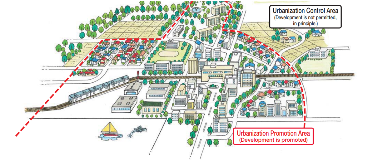
Figure 3. Diagram illustrating zoning in Japanese urban planning
Source: Ministry of Land, Infrastructure and Transport, Japan (2003)
Urban planning implementation in Japan employs three main tools:
1. Land registration: City authorities rigorously scrutinize each building or project to ensure full compliance with laws such as the Urban Planning Law, Construction Law, Reconstruction of Old Towns Act, Capital Construction Act, and other relevant regulations. Should a project exceed certain thresholds in scale, owners must seek government approval to proceed with construction.
2. Directly investment in infrastructure: The government directly invests in infrastructure projects.
3. Economic incentives: The government offers subsidies or preferential policies to incentivize companies or individuals.
For areas designated for urbanization, local authorities issue specific regulations to control the volume and height of structures, as well as usage, in accordance with the provisions outlined in the Construction Standards Law. These regulations aim to prevent the amalgamation of buildings serving different purposes within a single area and to ensure a conducive environment for each specific type of land use.
4. CONCLUSION
In recent years, the urbanization process has occurred at a rapid pace and the movement to build new rural areas has been promoted. It is forecast that in the period 2021 - 2030 and beyond, the trend of urban land fluctuations will continue to increase, with a rapid increase mainly for residential land in urban areas; Conversely, land in rural areas is anticipated to experience slower growth and a tendency towards decline due to ongoing urbanization processe. This trend has created requirements for allocating land funds for urban land in the process of preparing and adjusting land use planning. Resolution 18-NQ/TW of the XIII Central Committee sets out the need to innovate and improve the quality of planning and land use plans: "Determining land use criteria must be consistent with land use needs, avoid waste in land allocation, management and use” and “combining criteria of land types associated with space, land use zoning, and natural ecosystems, showing information for each plot land". Institutionalizing the above contents, the Ministry of Natural Resources and has formulated and finalized the revised Land Law draft, which encompasses regulations on land use norms outlined in provincial and district-level planning and land use plans. These norms will undergo further refinement and augmentation in subsequent revisions of the law.
Based on research on the experiences of the Federal Republic of Germany, China and Japan regarding urban land planning and management, it becomes evident that past practices necessitate an integration of spatial considerations, land use zoning, and preservation of natural ecosystems. This integration relies on clearly defined protection and conservation criteria coupled with management policies such as the exchange of development rights for non-agricultural investment projects. Urban land use planning hinges on two crucial elements: land use zoning for urban areas and the establishment of regulations, policies, and standards for each land use purpose. When paired with a rigorous and effective implementation process, this approach contributes to advancing urban areas towards modern, environmentally friendly standards, enhancing public transportation convenience, and realizing the objective of sustainable urban development.
Land use zoning aims to delineate boundaries and organize land use space into three categories: strictly managed areas, restricted areas, and areas with altered land use purposes. It governs the alignment of land use criteria with spatial configurations, determining the location, boundaries, land reclamation areas, and changes in land use purpose for each land parcel. In addition to zoning, research identifies criteria and standards for critical land purposes associated with spatial considerations, land use zoning, and natural ecosystems concerning residential and urban land. This comprehensive approach to urban land use planning serves as a vital foundation for accurately assessing needs, conditions, and development directions, thereby establishing specific norms for residential land at various planning levels. Ultimately, this contributes to enhancing the quality of land use planning and meeting the imperatives of sustainable development.
To Ngoc Vu
Department of Land Administration, Institute of Strategy and Policy on Natural Resources and Environment
(Source: Vietnam Environment Administration Magazine, English Edition I-2024)
REFERENCES
1. Resolution No. 18-NQ/TW, June 16, 2022, Fifth Conference of the 13th Party Central Committee on “continuing to innovate and complete institutions and policies to strengthen the efficiency and effectiveness in management and use of land, serving as the driving force in developing our country into a high-income economy”
2. Resolution No. 39/2021/QH15 of the 15th National Assembly on National Land Use Planning for the period 2021 - 2030, with a vision to 2050, 5-year National Land Use Plan 2021 - 2025
3. Resolution No. 148/NQ-CP dated November 11, 2022 of the Government Promulgating the Government’s Program of Action for
implementing the Political Bureau’s Resolution No. 06-NQ/TW of January 24, 2022 on planning, construction, management and sustainable development of Vietnamese urban centers up to 2030, with a vision toward 2045
4. Claus-C. Wiegandt et al (2000), Urban Development and Urban Policy in Germany - An Overview, Federal Office for Building and Regional Planning, ISSN 1436 – 0055
5. Junfang Xie et al (2019), Overview of urban planning policy and urban green space system at a national level in China. IOP Conf. Ser.: Earth Environ. Sci. 349 01202
6. MOHURD (2010), Classification standards of urban green space. (CJJ/T85-2010) In: Ministry of Housing and Urban-Rural Development of the People's Republic of China Beijing, China Architecture and Building Press
7. Ministry of Land, Infrastructure and Transport (2003), Urban Land Use Planning System in Japan
8. UN Habitat (2022). World Cities Report 2022: Envisaging the Future of Cities. ISBN Number: 978-92-1-133395-4